IMAGES TAKEN NEAR TO
Bradford Road, SHERBORNE, DT9 6SW
Introduction
This page details the photographs taken nearby to Bradford Road, DT9 6SW by members of the Geograph project.
The Geograph project started in 2005 with the aim of publishing, organising and preserving representative images for every square kilometre of Great Britain, Ireland and the Isle of Man.

There are currently over 7.5m images from over14,400 individuals and you can help contribute to the project by visiting https://www.geograph.org.uk
Image Map
Images are licensed for reuse under creativecommons.org/licenses/by-sa/2.0
Notes
- Clicking on the map will re-center to the selected point.
- The higher the marker number, the further away the image location is from the centre of the postcode.
Image Listing (12 Images Found)
Images are licensed for reuse under creativecommons.org/licenses/by-sa/2.0
Image
Details
Distance
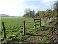
3
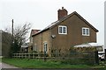
Agricultural Storage Tanks
These two tanks, one plastic the other metal are just on the other side of the access track from Lenthay Dairy Farm. The track stops just after the farm.
Image: © Nigel Mykura
Taken: 29 Mar 2011
0.03 miles
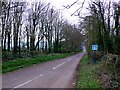
4
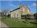
Lane to Lenthay Dairy House
Just off Bradford Road, (which leads to Bradford Abbas).
Image: © Steve Barnes
Taken: 23 Aug 2009
0.11 miles
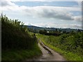
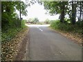
6
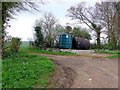
Road to Lenthay Dairy
This small dead end road runs south from the Sherborne to Bradford Abbas Rd. This is very close to the south east corner of the grid square which is just to the left of the road about 50m beyond the sign.
Image: © Nigel Mykura
Taken: 29 Mar 2011
0.14 miles
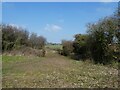
9
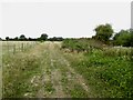
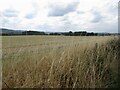
Lenthay Common
Taken during a mad dash to catch a train from Yeovil Junction. The line through Sherborne had closed due to shrinkage of the clay during a dry spell. The tracks on one embankment had been distorted. The path here (I had taken a wrong turn in Sherborne) had some big cracks in the clay too.
Image: © Richard Webb
Taken: 2 Sep 2022
0.20 miles