IMAGES TAKEN NEAR TO
Mapperton, BEAMINSTER, DT8 3NP
Introduction
This page details the photographs taken nearby to DT8 3NP by members of the Geograph project.
The Geograph project started in 2005 with the aim of publishing, organising and preserving representative images for every square kilometre of Great Britain, Ireland and the Isle of Man.

There are currently over 7.5m images from over14,400 individuals and you can help contribute to the project by visiting https://www.geograph.org.uk
Image Map (Loading...)


Getting Data...Please wait
Leaflet Map data © OpenStreetMap
Images are licensed for reuse under creativecommons.org/licenses/by-sa/2.0
Notes
- Clicking on the map will re-center to the selected point.
- The higher the marker number, the further away the image location is from the centre of the postcode.
Image Listing (19 Images Found)
Images are licensed for reuse under creativecommons.org/licenses/by-sa/2.0
Image
Details
Distance
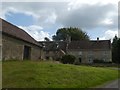
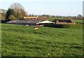
3
Marsh Farm
The range of buildings in the background was originally built in the late 17th century and much of it is grade II listed. However, the section at the right hand end was completely rebuilt following a fire in 1975, and is not listed.
Image: © Ian Capper
Taken: 15 Jul 2008
0.03 miles
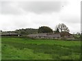
4
Marsh Farm, Marshwood
Looking left from the same spot as Image The farmhouse behind the modern barn is listed; it was burnt down in 1975 and rebuilt http://www.historicengland.org.uk/listing/the-list/list-entry/1220750 . Again the field is crossed by footpath W21 41.
Image: © Derek Harper
Taken: 22 Apr 2015
0.05 miles
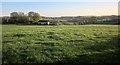
5
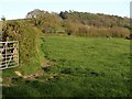
Countryside at Marshwood
Another view across the field that also appears in Image] and Image Footpath W21 41 cuts through the hedge on the left. The wood in the background is Remsmoor on the slopes of Cotleigh Hill.
Image: © Derek Harper
Taken: 22 Apr 2015
0.05 miles
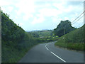
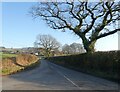
7
Road leading to Marsh Farm and Mapperton Manor
Image: © Val Ghose
Taken: 17 Feb 2007
0.08 miles
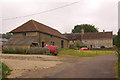
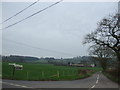
8
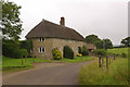
Marsh Farm Cottage
Grade II listed early 19th century pair of semi detached cottages, shown on maps as Marsh Farm Cottage but on listing details as Marshwood and Marsh End.
Image: © Ian Capper
Taken: 15 Jul 2008
0.09 miles
9
Cottages at Marshwood
A pair of attached thatched cottages http://www.historicengland.org.uk/listing/the-list/list-entry/1220586 seen from the B3163. The field is crossed by footpath W21 41.
Image: © Derek Harper
Taken: 22 Apr 2015
0.11 miles