IMAGES TAKEN NEAR TO
Barnes Meadow, LYME REGIS, DT7 3TD
Introduction
This page details the photographs taken nearby to Barnes Meadow, DT7 3TD by members of the Geograph project.
The Geograph project started in 2005 with the aim of publishing, organising and preserving representative images for every square kilometre of Great Britain, Ireland and the Isle of Man.

There are currently over 7.5m images from over14,400 individuals and you can help contribute to the project by visiting https://www.geograph.org.uk
Image Map
Images are licensed for reuse under creativecommons.org/licenses/by-sa/2.0
Notes
- Clicking on the map will re-center to the selected point.
- The higher the marker number, the further away the image location is from the centre of the postcode.
Image Listing (79 Images Found)
Images are licensed for reuse under creativecommons.org/licenses/by-sa/2.0
Image
Details
Distance
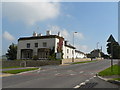
5
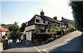
Cottages, Venlake, Uplyme
At the junction with Gore Lane.
Image: © Philip Pankhurst
Taken: 8 Jul 2013
0.08 miles
6
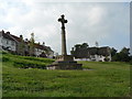
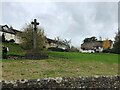
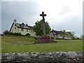
Uplyme: war memorial
The war memorial is on a grass bank to the west of the main road, overlooked by modern development.
Image: © Chris Downer
Taken: 27 Sep 2008
0.08 miles
7
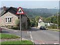
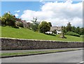
Uplyme: the B3165
Looking northwest along the main road through the village, the B3165 which was formerly the A3070, as it goes down the hill past the Image
Image: © Chris Downer
Taken: 27 Sep 2008
0.08 miles
8
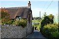
Gore Lane, Uplyme
A familiar walk for Hook Farm campers, leading to the Talbot Arms on the main road.
Image: © Philip Pankhurst
Taken: 16 Jul 2014
0.08 miles
9
Uplyme: Rohaise Court
This building was originally a rectory but a new one was built in 1935 elsewhere in the village. This became a hotel and has recently been converted into dwellings and named Rohaise Court, apparently a name unconnected with the history of the building, village or area.
Image: © Chris Downer
Taken: 27 Sep 2008
0.08 miles
10
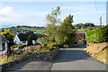
Gore Lane, Uplyme
A familiar walk for Hook Farm campers, leading to the Talbot Arms on the main road.
Image: © Philip Pankhurst
Taken: 16 Jul 2014
0.09 miles