IMAGES TAKEN NEAR TO
Charmouth, BRIDPORT, DT6 6RB
Introduction
This page details the photographs taken nearby to DT6 6RB by members of the Geograph project.
The Geograph project started in 2005 with the aim of publishing, organising and preserving representative images for every square kilometre of Great Britain, Ireland and the Isle of Man.

There are currently over 7.5m images from over14,400 individuals and you can help contribute to the project by visiting https://www.geograph.org.uk
Image Map
Images are licensed for reuse under creativecommons.org/licenses/by-sa/2.0
Notes
- Clicking on the map will re-center to the selected point.
- The higher the marker number, the further away the image location is from the centre of the postcode.
Image Listing (19 Images Found)
Images are licensed for reuse under creativecommons.org/licenses/by-sa/2.0
Image
Details
Distance
2
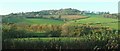
Char valley
East of Charmourh from the old main road, with the sewage works neatly screened by trees beside the river. The field to the left of the trees is mapped as a caravan park, but perhaps it is void because of the season. On the hill beyond are houses at the hamlet of Catherston Leweston, in Image On the right is a corner of Temperlands Copse.
Image: © Derek Harper
Taken: 31 Oct 2015
0.12 miles
3
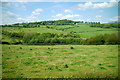
Char Valley
This is the valley of the river just west of the village. The river and the A35 village bypass run across the middle of the image. In the background is the hill of Catherston Leweston.
Image: © Nigel Mykura
Taken: 23 May 2015
0.12 miles
4
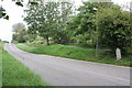
The road east from Charmouth towards the A35
On the right hand side of the image is an old milestone with an OS benchmark Image
Image: © Roger Templeman
Taken: 9 Sep 2012
0.12 miles
5
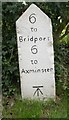
Old Milestone by the former A35, east of Charmouth
Carved stone post by the A35, in parish of STANTON ST GABRIEL (WEST DORSET District), East Charmouth, by Newlands Holiday Park. 30m before Stonebarrow Lane, on South side of road. Dorset 1 (limestone), erected by the Bridport - First District turnpike trust in the 19th century.
Inscription reads:-
6
to
Bridport
6
to
Axminster
Carved benchmark bottom of front face.
Milestone Society National ID: DO_AXBP06
Image: © Mike Faherty
Taken: 5 Sep 2007
0.13 miles
6
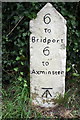
Benchmarked milestone at east end of Charmouth
Ordnance Survey cut mark benchmark described on the Bench Mark Database at http://www.bench-marks.org.uk/bm45352
Image: © Roger Templeman
Taken: 9 Sep 2012
0.13 miles
7
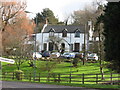
Stonebarrow Manor
Stonebarrow Manor is now a Holiday Home, this was taken looking up Stonebarrow Lane.
Image: © Jill Everington
Taken: 11 Feb 2007
0.14 miles
8
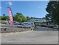
Approach to A35 from Charmouth
Charmouth has been bypassed by the A35 and this is where the minor road through the centre of the village meets the A35 on the north western side of the village.
Image: © Nigel Mykura
Taken: 23 May 2015
0.15 miles

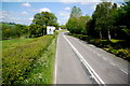
10
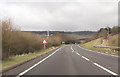
A35 Charmouth by pass, East end
Overbridge can be seen in the distance. Taken from about the bridge over the River Char
Image: © John Firth
Taken: 12 Apr 2013
0.15 miles