IMAGES TAKEN NEAR TO
Orchard Avenue, BRIDPORT, DT6 5RL
Introduction
This page details the photographs taken nearby to Orchard Avenue, DT6 5RL by members of the Geograph project.
The Geograph project started in 2005 with the aim of publishing, organising and preserving representative images for every square kilometre of Great Britain, Ireland and the Isle of Man.

There are currently over 7.5m images from over14,400 individuals and you can help contribute to the project by visiting https://www.geograph.org.uk
Image Map (Loading...)


Getting Data...Please wait
Leaflet Map data © OpenStreetMap
Images are licensed for reuse under creativecommons.org/licenses/by-sa/2.0
Notes
- Clicking on the map will re-center to the selected point.
- The higher the marker number, the further away the image location is from the centre of the postcode.
Image Listing (19 Images Found)
Images are licensed for reuse under creativecommons.org/licenses/by-sa/2.0
Image
Details
Distance
1
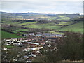
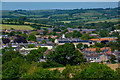
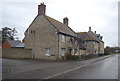
View NNE from Allington Hill
View from Allington Hill with North Allington in the immediate foreground and Court Orchard and Dibden View behind.
Image: © John Stephen
Taken: 20 Feb 2017
0.06 miles
3
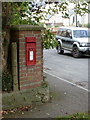
Bridport: postbox № DT6 95, Allington Mead
This George VI-reign postbox is set into a brick pillar at the junction of Allington Mead (ahead) and Court Orchard Road, and is emptied at 4pm on weekdays and at noon on Saturdays.
Image: © Chris Downer
Taken: 10 Oct 2011
0.16 miles
4
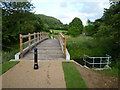
Footbridge and cycle route over the River Brit (opened 2011)
Built to link new houses on the western side of the river with schools and houses on the eastern side, the bridge also provides a link to footpaths and a cycle route.
Image: © Maurice D Budden
Taken: 18 Jun 2011
0.17 miles
5
Bridport : Bridport Scenery
Looking across the town of Bridport.
Image: © Lewis Clarke
Taken: 26 May 2020
0.18 miles
6
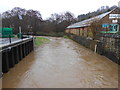
River Brit in spate
The river here flows through the old industrial part of Bridport. On the right of the river can be seen a flood level indicator and opposite it on the left can be seen a water level measuring device. The device is powered by the solar panels above and to the left of it. The picture was taken from the bridge where North Mills Road crosses the river.
Image: © Nigel Mykura
Taken: 9 Feb 2013
0.19 miles
7
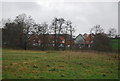
New Houses Pymore Road
These new houses are built on the now demolished St Cecilias Convent site.
Image: © Ray Beer
Taken: 6 May 2007
0.19 miles
8
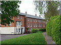
Georgian style house, St Cecilia's Gardens
Image: © N Chadwick
Taken: 1 Jan 2012
0.20 miles
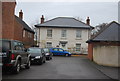
10
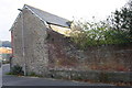
Cider Barn, Parsonage Road
On the wall above the gas marker stone is an OS benchmark Image
Image: © Roger Templeman
Taken: 20 Nov 2011
0.21 miles