IMAGES TAKEN NEAR TO
Simene Close, BRIDPORT, DT6 5JS
Introduction
This page details the photographs taken nearby to Simene Close, DT6 5JS by members of the Geograph project.
The Geograph project started in 2005 with the aim of publishing, organising and preserving representative images for every square kilometre of Great Britain, Ireland and the Isle of Man.

There are currently over 7.5m images from over14,400 individuals and you can help contribute to the project by visiting https://www.geograph.org.uk
Image Map
Images are licensed for reuse under creativecommons.org/licenses/by-sa/2.0
Notes
- Clicking on the map will re-center to the selected point.
- The higher the marker number, the further away the image location is from the centre of the postcode.
Image Listing (39 Images Found)
Images are licensed for reuse under creativecommons.org/licenses/by-sa/2.0
Image
Details
Distance
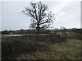
1
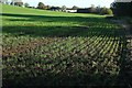
Young crop near Allington
Footpath W3 8 is mapped as running through the middle of this crop, so I am sticking to the edge of the field, as there is no visible path. But I will have to cross it eventually to reach the end of the path and West Road. The terraced housing ahead is on Simene Close, and I have to be to the left of it. The River Simene is about 10 metres to my right.
Image: © Derek Harper
Taken: 31 Oct 2015
0.08 miles
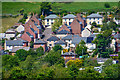
2
West of Bridport
From the farm track shown in Image The houses are on the B3162 West End (once the main A35), or on closes off it. Left of centre are the thatched houses shown in Image In the background is Allington Hill.
Image: © Derek Harper
Taken: 31 Oct 2015
0.09 miles
3
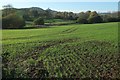
Simene valley
Seen from footpath W3 8 behind the terraced housing on Simene Close seen in Image The path should head out across this crop, remaining at least 50 metres from the river but roughly parallel to it, according to the maps. Across the river are Ryberry Hill, Sloes Hill, and the pine-topped Colmer's Hill.
Image: © Derek Harper
Taken: 31 Oct 2015
0.11 miles
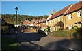
4
Cottages in Bridport
These are situated on West Road by the junction with Lodge Lane.
Image: © Shazz
Taken: 6 Jul 2012
0.11 miles
5
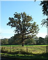
Tree west of Bridport
The tree is prominent in Image], a view from another direction. This is taken from the B3162, West End. The trees in the background are along the River Simene.
Image: © Derek Harper
Taken: 31 Oct 2015
0.11 miles
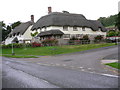
6
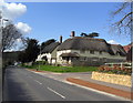
Housing on West Road, Bridport
A modern development of housing on the western edge of Bridport. Many of the houses are thatched.
Image: © Stephen Williams
Taken: 13 Mar 2007
0.11 miles
7
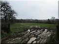
Development land, Vearse Farm
This waterlogged land is south of the B3162 West Allington and will be part of the Vearse Farm development of 760 dwellings, employment units, shops, a pub, school and old people's home. The plan is currently in the detailed design stages, and was agreed in principle by the West Dorset District Council despite vehement opposition from the local town and parish councils and population. One of the many objections raised was that of flooding and water run off.
Image: © John Stephen
Taken: 15 Mar 2018
0.13 miles
8
Development land, Vearse Farm
This waterlogged land is south of the B3162 West Allington and will be part of the Vearse Farm development of 760 dwellings, employment units, shops, a pub, school and old people's home. The plan is currently in the detailed design stages, and was agreed in principle by the West Dorset District Council despite vehement opposition from the local town and parish councils and population. One of the many objections raised was that of flooding and water run off.
Image: © John Stephen
Taken: 15 Mar 2018
0.13 miles
9
Bridport : Bridport Scenery
Looking towards houses on the suburbs of Bridport.
Image: © Lewis Clarke
Taken: 26 May 2020
0.14 miles
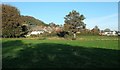
10
Lodge Lane, Bridport
A cul-de-sac of modern houses that leads to a few others, on the slopes of Allington Hill.
Image: © Derek Harper
Taken: 31 Oct 2015
0.14 miles