IMAGES TAKEN NEAR TO
Dorchester Road, BRIDPORT, DT6 4NZ
Introduction
This page details the photographs taken nearby to Dorchester Road, DT6 4NZ by members of the Geograph project.
The Geograph project started in 2005 with the aim of publishing, organising and preserving representative images for every square kilometre of Great Britain, Ireland and the Isle of Man.

There are currently over 7.5m images from over14,400 individuals and you can help contribute to the project by visiting https://www.geograph.org.uk
Image Map
Images are licensed for reuse under creativecommons.org/licenses/by-sa/2.0
Notes
- Clicking on the map will re-center to the selected point.
- The higher the marker number, the further away the image location is from the centre of the postcode.
Image Listing (27 Images Found)
Images are licensed for reuse under creativecommons.org/licenses/by-sa/2.0
Image
Details
Distance
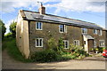
1
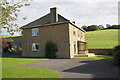
Uploders Farm
There is an OS flush bracket benchmark http://www.bench-marks.org.uk/bm10116 Image on the face of the house by the downpipe
Image: © Roger Templeman
Taken: 19 Sep 2012
0.01 miles
2
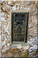
Ordnance Survey flush bracket on Uploders Farm
Information on this bracket, serial number 2115, and similar benchmarks nearby is on the Bench Mark Database at http://www.bench-marks.org.uk/bm10116
Image: © Roger Templeman
Taken: 19 Sep 2012
0.01 miles
3
Ordnance Survey Flush Bracket 2115
This mark can be found on the wall of Uploders Farm.
For more detail see : http://www.bench-marks.org.uk/bm10116
Image: © Peter Wood
Taken: 1 Apr 2014
0.02 miles
4
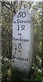
The A35 (Dorchester Road) at milestone 50 to Salisbury
There was an OS benchmark Image on the milestone but it has been removed
Image: © Roger Templeman
Taken: 19 Sep 2012
0.07 miles
5
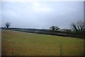
Locks Lane near Vinney Cross
The lane is between the two linear hedges.
Image: © N Chadwick
Taken: 28 Dec 2011
0.09 miles
6
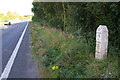
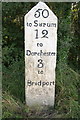
Old Milestone by the A35, west of Vinney Cross
Carved stone post by the A35, in parish of LODERS (WEST DORSET District), South of Uploders, on A35 300m from Uploders turnoff. By start of Armco Barrier, on South side of road. Dorset 1 (limestone), erected by the Harnham, Blandford & Dorchester turnpike trust in the 19th century.
Inscription reads:-
50
to Sarum
12
to
Dorchester
3
to
Bridport
Milestone Society National ID: DO_BPDO03.
Image: © Mike Richards
Taken: 22 Aug 2002
0.10 miles
7
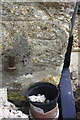
Milestone on south side of A35
There was an Ordnance Survey cut mark benchmark between 'Bridport' and the ground which has been chiselled off. The mark is described on the Bench Mark Database at http://www.bench-marks.org.uk/bm28991
Image: © Roger Templeman
Taken: 19 Sep 2012
0.11 miles
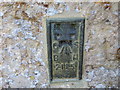
8
Benchmark on converted barn at Higher Uploders Farm
Ordnance Survey cut mark benchmark described on the Bench Mark Database at http://www.bench-marks.org.uk/bm45529
Image: © Roger Templeman
Taken: 19 Sep 2012
0.11 miles
9
House at end of Locks Lane, Vinney Cross
There may be an 1850 Ordnance Survey benchmark, http://www.bench-marks.org.uk/bm29083 on the front corner of the building behind the white buttress.
Image: © Roger Templeman
Taken: 19 Sep 2012
0.12 miles
10
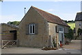
Barn conversion at Higher Uploders Farm
There is an OS benchmark Image on the front right corner of the building
Image: © Roger Templeman
Taken: 19 Sep 2012
0.12 miles