IMAGES TAKEN NEAR TO
Flood Lane, DT6 3FZ
Introduction
This page details the photographs taken nearby to Flood Lane, DT6 3FZ by members of the Geograph project.
The Geograph project started in 2005 with the aim of publishing, organising and preserving representative images for every square kilometre of Great Britain, Ireland and the Isle of Man.

There are currently over 7.5m images from over14,400 individuals and you can help contribute to the project by visiting https://www.geograph.org.uk
Image Map
Images are licensed for reuse under creativecommons.org/licenses/by-sa/2.0
Notes
- Clicking on the map will re-center to the selected point.
- The higher the marker number, the further away the image location is from the centre of the postcode.
Image Listing (225 Images Found)
Images are licensed for reuse under creativecommons.org/licenses/by-sa/2.0
Image
Details
Distance
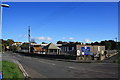
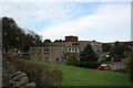
2
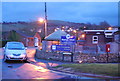
Bridport: postbox № DT6 17, West Bay Road
This little postbox stands outside Mountjoy School, a special school at the south end of Bridport. Ahead we see the roundabout where West Bay Road continues top-right to the village of West Bay. The postbox is emptied at 4pm on weekdays and at noon on Saturdays.
Image: © Chris Downer
Taken: 13 Jun 2009
0.02 miles
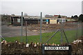
3

Mountjoy School demolition in progress
View from Flood Lane of demolition of Mountjoy School for special needs children which moved to Beaminster at the end of October, looking towards the Crown roundabout on the A35. Behind the school is Sidney Gale House which is a nursing home run by the council. It is rumoured that plans are afoot to build a motel on the school site, though an extension/modernisation of the nursing home would be preferred by many.
Image: © John Stephen
Taken: 8 Jan 2013
0.02 miles
4
Mountjoy School demolition in progress
What was until the end of October 2012, Mountjoy School, Bridport. The school moved to Beaminster in November and demolition started before` Christmas. For view of school as was see Image
Image: © John Stephen
Taken: 8 Jan 2013
0.02 miles
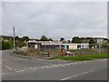
5
Mountjoy School
Mountjoy School with Sidney Gale House behind from West Bay Road. The roadsigns for The Crown roundabout on the A35 are on the right. The school is due to close and move to Beaminster at the end of the month.
Image: © John Stephen
Taken: 19 Oct 2012
0.02 miles
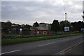
6
Mountjoy School, Bridport
Mountjoy School on Flood Lane off West Bay Road is a local authority run school for children with special needs. It is due to move to new buildings with bigger and better facilities in Beaminster by the end of October.
Image: © John Stephen
Taken: 14 Oct 2012
0.03 miles
7
Bridport, former school
At the corner of Flood Lane and West Bay Road, once Mountjoy School, which has now relocated to Beaminster: http://www.dorsetecho.co.uk/news/10006949.Kids_wave_goodbye_to_Mountjoy_School_in_Bridport/
Image: © Mike Faherty
Taken: 22 Sep 2013
0.03 miles
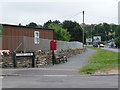
8
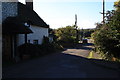
Flood Lane, Bridport
View of Flood Lane looking west from the wall at the end towards West Bay Road. The path from the A35 comes in at the extreme front right.
Image: © John Stephen
Taken: 14 Oct 2012
0.03 miles
9
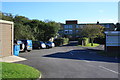
Sidney Gale House, Bridport
The entrance to Sidney Gale House, Flood Lane, Bridport. Sidney Gale House is a residential care home run by the local authority. On the right is the end of the Mountjoy School building.
Image: © John Stephen
Taken: 14 Oct 2012
0.03 miles
10
Sidney Gale House
Sidney Gale house viewed from Sea Road South. It is a local authority run nursing home.
Image: © John Stephen
Taken: 19 Oct 2012
0.04 miles