IMAGES TAKEN NEAR TO
Higher Street, BRIDPORT, DT6 3EU
Introduction
This page details the photographs taken nearby to Higher Street, DT6 3EU by members of the Geograph project.
The Geograph project started in 2005 with the aim of publishing, organising and preserving representative images for every square kilometre of Great Britain, Ireland and the Isle of Man.

There are currently over 7.5m images from over14,400 individuals and you can help contribute to the project by visiting https://www.geograph.org.uk
Image Map
Images are licensed for reuse under creativecommons.org/licenses/by-sa/2.0
Notes
- Clicking on the map will re-center to the selected point.
- The higher the marker number, the further away the image location is from the centre of the postcode.
Image Listing (85 Images Found)
Images are licensed for reuse under creativecommons.org/licenses/by-sa/2.0
Image
Details
Distance
2
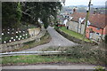
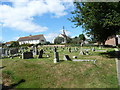
Middle Street Bradpole
Looking down Middle Street from the parish churchyard. Village Road runs across the lower part of the image. Above the raised footpath on the left can be seen the square plates on the ends of the rods used recently to stabilise the soil on the steep bank.
Image: © Nigel Mykura
Taken: 11 Feb 2017
0.03 miles
3
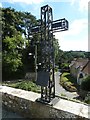
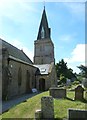
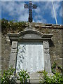
Holy Trinity, Bradpole: cross on the churchyard wall
Image: © Basher Eyre
Taken: 2 Sep 2013
0.03 miles
4
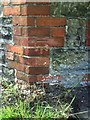
Benchmark on house at junction of Village Street and Higher Street
Ordnance Survey cut mark benchmark described on the Bench Mark Database at http://www.bench-marks.org.uk/bm25146
Image: © Roger Templeman
Taken: 22 Sep 2010
0.03 miles
5
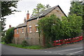
House at junction of Higher Street and Village Street
There is an OS benchmark Image on the red bricks of the angled-corner of the house
Image: © Roger Templeman
Taken: 19 Sep 2012
0.03 miles
7
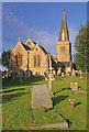
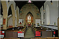
Holy Trinity Church, Bradpole
This Grade II listed church was built in 1845-6 on a different site to the original church, which was apparently "in a dilapidated state and totally inadequate to the wants of the population". The spire was added to the tower in 1863 and the church was enlarged in 1897 with the addition of a north-east chapel/vestry.
Image: © Ian Capper
Taken: 16 Jul 2008
0.04 miles