IMAGES TAKEN NEAR TO
St. Andrews Road, BRIDPORT, DT6 3BU
Introduction
This page details the photographs taken nearby to St. Andrews Road, DT6 3BU by members of the Geograph project.
The Geograph project started in 2005 with the aim of publishing, organising and preserving representative images for every square kilometre of Great Britain, Ireland and the Isle of Man.

There are currently over 7.5m images from over14,400 individuals and you can help contribute to the project by visiting https://www.geograph.org.uk
Image Map
Images are licensed for reuse under creativecommons.org/licenses/by-sa/2.0
Notes
- Clicking on the map will re-center to the selected point.
- The higher the marker number, the further away the image location is from the centre of the postcode.
Image Listing (37 Images Found)
Images are licensed for reuse under creativecommons.org/licenses/by-sa/2.0
Image
Details
Distance
1
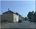
St Andrew's Industrial Estate, Bradpole
Image: © David Smith
Taken: 26 Aug 2020
0.03 miles
2
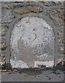
Old Milestone by the A3066, St Andrew's Road, Bradpole
Carved stone post by the A3066, in parish of BRADPOLE (WEST DORSET District), Bridport; 10m South of turning to Knightstone Rise. Set into wall on North side of road. Dorset 3 (limestone), erected by the Bridport - Second District turnpike trust in the 19th century.
Inscription reads:-
5
B
(To Beaminster)
Milestone Society National ID: DO_BEBP05
Image: © Mike Faherty
Taken: 12 Jan 2008
0.06 miles
3
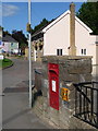
Bridport: postbox № DT6 38, St. Andrew?s Road
This George V-reign postbox is set into a wall on the main road to Beaminster. It is in the area known as St. Andrew's Well and the building in the distance, which looks like a former pub, is called The Well and is now a b&b.
The box is emptied finally at 4:45pm on weekdays and at noon on Saturdays.
Image: © Chris Downer
Taken: 12 Sep 2009
0.07 miles
4
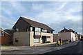
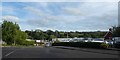
Office building, Sea Road North, Bradpole
I wonder what design feature inspired the window design on the first floor
Image: © David Smith
Taken: 26 Aug 2020
0.08 miles
6
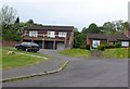
Knightstone Rise
This road is a recent cul-de-sac development of modern detached houses on the eastern slopes of Watton Hill on the northern edge of Bridport.
Image: © Nigel Mykura
Taken: 4 May 2011
0.12 miles
7
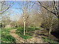
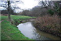
Footpath at Bradpole
This public footpath starts near the old level crossing at Bradpole and largely follows the course of the old railway line which closed in the 1970s.
Image: © Stephen Williams
Taken: 4 Apr 2007
0.13 miles
8
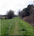
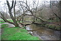
Old railway track-bed near Bridport
This is the old track-bed of the railway from Maiden Newton to Bridport which closed in the 1970s. Parts of it remain as a public footpath.
Image: © Stephen Williams
Taken: 4 Apr 2007
0.13 miles