IMAGES TAKEN NEAR TO
Osbourne Road, BRIDPORT, DT6 3AN
Introduction
This page details the photographs taken nearby to Osbourne Road, DT6 3AN by members of the Geograph project.
The Geograph project started in 2005 with the aim of publishing, organising and preserving representative images for every square kilometre of Great Britain, Ireland and the Isle of Man.

There are currently over 7.5m images from over14,400 individuals and you can help contribute to the project by visiting https://www.geograph.org.uk
Image Map
Images are licensed for reuse under creativecommons.org/licenses/by-sa/2.0
Notes
- Clicking on the map will re-center to the selected point.
- The higher the marker number, the further away the image location is from the centre of the postcode.
Image Listing (42 Images Found)
Images are licensed for reuse under creativecommons.org/licenses/by-sa/2.0
Image
Details
Distance
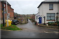
2
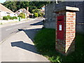
Bridport: postbox № DT6 90, Victoria Grove
This George VI-reign postbox, on the corner of Osborne Road up which we are looking, is emptied finally at 4pm on weekdays and at noon on Saturdays.
Image: © Chris Downer
Taken: 12 Sep 2009
0.06 miles
3
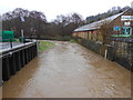
River Brit in spate
The river here flows through the old industrial part of Bridport. On the right of the river can be seen a flood level indicator and opposite it on the left can be seen a water level measuring device. The device is powered by the solar panels above and to the left of it. The picture was taken from the bridge where North Mills Road crosses the river.
Image: © Nigel Mykura
Taken: 9 Feb 2013
0.08 miles
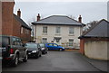
4
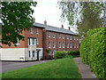
New Houses Pymore Road
These new houses are built on the now demolished St Cecilias Convent site.
Image: © Ray Beer
Taken: 6 May 2007
0.09 miles
5
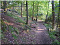
Mountfield and Coneygar Hill Millennium Green - path through the wood
The Millennium Green comprises a comparatively formal area around the council offices at Mountfield, this wood and a field which is periodically grazed by cattle.
Image: © Maurice D Budden
Taken: 3 Jun 2013
0.09 miles
6
Georgian style house, St Cecilia's Gardens
Image: © N Chadwick
Taken: 1 Jan 2012
0.10 miles
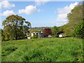
8
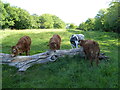
Mountfield and Coneygar Hill Millennium Green
The Millennium Green comprises a comparatively formal area around the council offices at Mountfield, a wood and this field, which is here being grazed by cattle.
Image: © Maurice D Budden
Taken: 12 May 2020
0.12 miles
9
Mountfield and Coneygar Hill Millennium Green
The Millennium Green comprises a comparatively formal area around the council offices at Mountfield, an area of woodland and this field, which is periodically grazed by cattle.
Image: © Maurice D Budden
Taken: 9 May 2005
0.12 miles
10
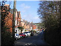
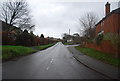
Victoria Grove, Bridport from the top of North St.
Victoria Grove looking north from the spot where North Street joins it. This area was a Victorian residential development with views over the Brit valley to the west..
Image: © Stephen Williams
Taken: 6 Mar 2007
0.12 miles