IMAGES TAKEN NEAR TO
Tillycombe Road, PORTLAND, DT5 1LL
Introduction
This page details the photographs taken nearby to Tillycombe Road, DT5 1LL by members of the Geograph project.
The Geograph project started in 2005 with the aim of publishing, organising and preserving representative images for every square kilometre of Great Britain, Ireland and the Isle of Man.

There are currently over 7.5m images from over14,400 individuals and you can help contribute to the project by visiting https://www.geograph.org.uk
Image Map
Images are licensed for reuse under creativecommons.org/licenses/by-sa/2.0
Notes
- Clicking on the map will re-center to the selected point.
- The higher the marker number, the further away the image location is from the centre of the postcode.
Image Listing (274 Images Found)
Images are licensed for reuse under creativecommons.org/licenses/by-sa/2.0
Image
Details
Distance
1
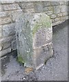
Old Boundary Marker by New Road, Fortuneswell
Estate Boundary Marker - War Department by the A354, in parish of Portland (Weymouth and Portland District), New Road/Fortuneswell, at junction with Verne Hill Road, against wall.
Inscription reads:-
: ^ / W D : : 33 :
Dorset HER.
HER Number: MDO31663 https://www.heritagegateway.org.uk/Gateway/Results_Single.aspx?uid=MDO31663&resourceID=1012
Surveyed
Milestone Society National ID: DO_WDPOR33em
Image: © Milestone Society
Taken: Unknown
0.01 miles
2
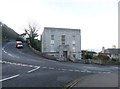
Fortuneswell, former council offices
At the junction of New Road and Fortuneswell; once the seat of Portland Urban District Council. The building is dated 1935.
Image: © Mike Faherty
Taken: 24 Jan 2015
0.02 miles

4

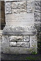
Benchmark on Portland Town Council Offices
Ordnance Survey cut mark benchmark described on the Bench Mark Database at http://www.bench-marks.org.uk/bm40290
Image: © Roger Templeman
Taken: 21 Nov 2011
0.02 miles
5

Portland Town Council Offices, Fortuneswell
There is an OS benchmark Image on the front right hand corner
Image: © Roger Templeman
Taken: 21 Nov 2011
0.02 miles

7
Benchmark on buttress of Underhill Methodist Church
Ordnance Survey cut mark benchmark described on the Bench Mark Database at http://www.bench-marks.org.uk/bm40281
Image: © Roger Templeman
Taken: 21 Nov 2011
0.04 miles
8
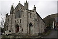
Underhill Methodist Church
There is an OS benchmark Image on the facing buttress on the front right hand corner of the church.
Image: © Roger Templeman
Taken: 21 Nov 2011
0.04 miles
9

Old Boundary Marker by the A354, New Road, Portland parish
Estate Boundary Marker - War Department by the A354, in parish of Portland (Weymouth and Portland District), New Road, 10m South of junction with Old Hill, inset in wall.
Grade II listed.
List Entry Number: 1281866 https://historicengland.org.uk/listing/the-list/list-entry/1281866
Surveyed
Milestone Society National ID: DO_WDPOR31em
Image: © Milestone Society
Taken: Unknown
0.04 miles
10

Benchmark on wall of New Road
Ordnance Survey cut mark benchmark described on the Bench Mark Database at http://www.bench-marks.org.uk/bm40299
Image: © Roger Templeman
Taken: 22 Nov 2011
0.04 miles