IMAGES TAKEN NEAR TO
Lerret Road, PORTLAND, DT5 1GB
Introduction
This page details the photographs taken nearby to Lerret Road, DT5 1GB by members of the Geograph project.
The Geograph project started in 2005 with the aim of publishing, organising and preserving representative images for every square kilometre of Great Britain, Ireland and the Isle of Man.

There are currently over 7.5m images from over14,400 individuals and you can help contribute to the project by visiting https://www.geograph.org.uk
Image Map
Images are licensed for reuse under creativecommons.org/licenses/by-sa/2.0
Notes
- Clicking on the map will re-center to the selected point.
- The higher the marker number, the further away the image location is from the centre of the postcode.
Image Listing (186 Images Found)
Images are licensed for reuse under creativecommons.org/licenses/by-sa/2.0
Image
Details
Distance
1
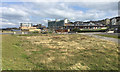
Vacant site at Osprey Quay
Apartment block, new buildings, and Portland Castle on the left.
Image: © Peter Barr
Taken: 1 May 2013
0.07 miles
2
Lerret Road, Portland
Looking north-eastward.
Image: © Peter Wood
Taken: 5 Jun 2016
0.07 miles
3
Looking up to Verne Citadel
From near Victoria Square
Image: © Chris Gunns
Taken: 25 May 2009
0.07 miles
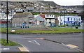
4
Fortuneswell, Lerret Road
Fortuneswell is a village on the Isle of Portland. It lies on steeply sloping land on the northern edge of the island, known as Underhill, where Chesil Beach, which connects the island to the mainland, joins the island. Fortuneswell has a main shopping street, and along with Easton, is the main hub of the Isle of Portland's activities.
Image: © David Dixon
Taken: 30 May 2017
0.07 miles
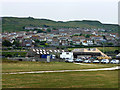
5
![Portland and Chesil Beach [3]](https://s0.geograph.org.uk/geophotos/06/78/29/6782992_7497537a_120x120.jpg)
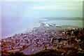
Portland and Chesil Beach [3]
Seen from near the war memorial Image is this view over Fortuneswell toward Portland Harbour with Weymouth in the distance.
The Isle of Portland is a tied island, some 5 miles south of the resort of Weymouth, the southernmost point of the county of Dorset, joined to the mainland by Chesil Beach. The Isle has been inhabited since at least the Mesolithic period. Portland stone, a limestone famous for its use in world architecture is quarried here. Portland Harbour, is one of the largest man-made harbours in the world. Chesil Beach, a barrier beach, runs for 18 miles from West Bay to the Isle of Portland and in places is 50 feet high and 650 feet wide.
Image: © Michael Dibb
Taken: 11 Dec 2020
0.08 miles
6
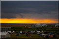
View over Fortuneswell towards Chesil Bank from New Ground, Portland Bill, 1981
The rows of tanks in the middle distance have since been replaced by industrial units.
Image: © Nigel Thompson
Taken: 30 Jul 1981
0.09 miles
7
Camping ground near Chesil Beach
This is a spectacular setting for camping!
Image: © Ceri Thomas
Taken: 15 Jul 2007
0.09 miles
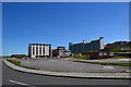
8
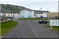
Mixed development near Osprey Quay, Portland
Former naval land at the flat northwest end of Portland appears to be developing in a piecemeal way. Roads such as Lerret Road, left, have been laid out but the spaces between them seem slow to fill. Maritime, industrial and commercial businesses and services are present or under construction. Nearest the camera on the right is a school: the Osprey Quay campus of Atlantic Academy Portland, a co-educational through school and sixth form for ages 3-19. In the background are blocks of private apartments, formerly accommodation for naval personnel: Image
Image: © Robin Stott
Taken: 17 Sep 2017
0.10 miles
9
Ordnance Survey Flush Bracket 11779
This can be found on the wall of a building in Victoria Square, Portland.
For more detail see : http://www.bench-marks.org.uk/bm21578
Image: © Peter Wood
Taken: 5 Jun 2016
0.10 miles