IMAGES TAKEN NEAR TO
Lynch Lane, DT4 9GR
Introduction
This page details the photographs taken nearby to Lynch Lane, DT4 9GR by members of the Geograph project.
The Geograph project started in 2005 with the aim of publishing, organising and preserving representative images for every square kilometre of Great Britain, Ireland and the Isle of Man.

There are currently over 7.5m images from over14,400 individuals and you can help contribute to the project by visiting https://www.geograph.org.uk
Image Map
Images are licensed for reuse under creativecommons.org/licenses/by-sa/2.0
Notes
- Clicking on the map will re-center to the selected point.
- The higher the marker number, the further away the image location is from the centre of the postcode.
Image Listing (147 Images Found)
Images are licensed for reuse under creativecommons.org/licenses/by-sa/2.0
Image
Details
Distance
1
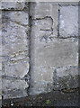
Benchmark on the bridge wall
A cutmark, as listed in the Benchmark Database: http://www.bench-marks.org.uk/bm61308 , on the end of a wall that is part of the old railway bridge over Wyke Road. See Image] for a wider view.
Image: © Neil Owen
Taken: 3 Sep 2014
0.01 miles
2
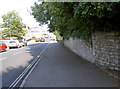
Wyke Road
Looking downhill as the road spans the old GW & L&SW railway bridge. See Image] for a benchmark on the joint of the wall to the right,
Image: © Neil Owen
Taken: 3 Sep 2014
0.02 miles
3
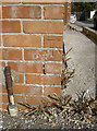
Glen Avenue benchmark
Lurking in a quiet cul-de-sac on the corner of a modern house is a cutmark. It is listed in the Benchmark Database: http://www.bench-marks.org.uk/bm60546 .
Image: © Neil Owen
Taken: 3 Sep 2014
0.02 miles
4
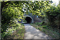
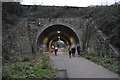
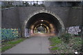
Rodwell railway tunnel on the Rodwell Trail
The short tunnel carried the railway under Wyke Road. The substantial tunnel was widened in the early 1900s when the Great Western Railway doubled the track through here. The double tracked Rodwell station site is just the other end of the tunnel and the platforms survive.
Image: © John Lucas
Taken: 14 Oct 2020
0.02 miles
6
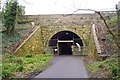
Tunnel Under Wyke Road
This tunnel was on the Weymouth and Portland Railway line. The line closed to passengers in 1952, however freight trains ran until 1965. The track bed is now a public footpath and cycle way. Note that the tunnel is undergoing repairs, but remains open.
Image: © mike smith
Taken: 17 Mar 2012
0.03 miles
7
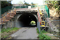
Rodwell tunnel looking north
Some remedial work is being carried out.
Image: © John Lucas
Taken: 14 Oct 2020
0.03 miles
8
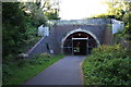
Wyke Road Tunnel
The Rodwell Trail following the path of the old Weymouth-Portland railway line goes under Wyke Road through this 58 yard long tunnel. Viewed from the north side.
Image: © John Stephen
Taken: 5 Sep 2012
0.03 miles
10
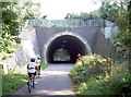
The Rodwell Trail
National Cycle Route 26, taking the old railway line from Weymouth to Portland. This is the Wyke Road bridge.
Image: © Neil Owen
Taken: 3 Sep 2014
0.04 miles