IMAGES TAKEN NEAR TO
Wellington Court, WEYMOUTH, DT4 8UA
Introduction
This page details the photographs taken nearby to Wellington Court, DT4 8UA by members of the Geograph project.
The Geograph project started in 2005 with the aim of publishing, organising and preserving representative images for every square kilometre of Great Britain, Ireland and the Isle of Man.

There are currently over 7.5m images from over14,400 individuals and you can help contribute to the project by visiting https://www.geograph.org.uk
Image Map (Loading...)


Getting Data...Please wait
Leaflet Map data © OpenStreetMap
Images are licensed for reuse under creativecommons.org/licenses/by-sa/2.0
Notes
- Clicking on the map will re-center to the selected point.
- The higher the marker number, the further away the image location is from the centre of the postcode.
Image Listing (1505 Images Found)
Images are licensed for reuse under creativecommons.org/licenses/by-sa/2.0
Image
Details
Distance
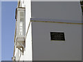
1
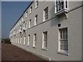
Weymouth - Wellington Court
Wellington Court was formerly the "Red Barracks" which was built in 1794-1803 at a time of threatened French invasion. They remained in military use for over 150 years. They have now been converted into homes.
Image: © Chris Talbot
Taken: 27 Mar 2011
0.02 miles
2
Weymouth - Wellington Court
Wellington Court was formerly the "Red Barracks" which was built in 1794-1803 at a time of threatened French invasion. They remained in military use for over 150 years. They have now been converted into homes.
Image: © Chris Talbot
Taken: 27 Mar 2011
0.02 miles
3
Weymouth - Wellington Court
Converted former military building.
Wellington Court was formerly the "Red Barracks" which was built in 1794-1803 at a time of threatened French invasion. They remained in military use for over 150 years. They have now been converted into homes.
Image: © Chris Talbot
Taken: 27 Mar 2011
0.02 miles
4
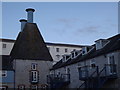
Old Oast Houses, Weymouth
The former Devenish Brewery in Brewers Quay is now converted into leisure and residential use. These oasts are now holiday accommodation.
http://en.wikipedia.org/wiki/Weymouth,_Dorset
Image: © Colin Smith
Taken: 15 Jan 2012
0.02 miles
5

Cove Street, Weymouth, Dorset
Lovely old cottages with mansart roofs.
Image: © Christine Matthews
Taken: 12 Aug 2010
0.02 miles
6
Wellington Court
The area to the west of Nothe Fort used to be barracks for hundreds of soldiers. This block is now residential. See Image] for a suitably named pub nearby.
Image: © Neil Owen
Taken: 2 Sep 2013
0.02 miles
7
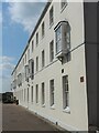
Bay windows on the barracks
Weymouth old military buildings are now a prime residential location. Originally the 'Red Baracks' the buildings were occupied from the very late eighteenth century until the post-WWII era.
Image: © Neil Owen
Taken: 16 Jul 2021
0.02 miles
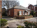
8
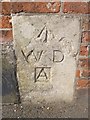
Old Boundary Marker by Barrack Road, Weymouth
Estate Boundary Marker - War Department 'A', by the UC road, in parish of Weymouth (Weymouth And Portland District), Barrack Road, Inset into wall next to Military Arms Hotel.
Surveyed
Milestone Society National ID: DO_WDNOTAem
Image: © Mike Faherty
Taken: 12 Oct 2013
0.02 miles
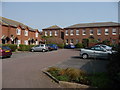
9
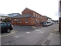
Weymouth, former barracks
Nothe Barracks, on Barrack Road; formerly used by Royal Artillery. Some is still MoD property (this block), some is used by sea cadets and Image, and some private residential.
Image: © Mike Faherty
Taken: 12 Oct 2013
0.03 miles
10
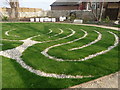
Weymouth - Peace Garden
This peace garden has been built on top of the old Quaker burial ground.
Image: © Chris Talbot
Taken: 27 Mar 2011
0.03 miles