IMAGES TAKEN NEAR TO
Canterbury Close, WEYMOUTH, DT4 0SZ
Introduction
This page details the photographs taken nearby to Canterbury Close, DT4 0SZ by members of the Geograph project.
The Geograph project started in 2005 with the aim of publishing, organising and preserving representative images for every square kilometre of Great Britain, Ireland and the Isle of Man.

There are currently over 7.5m images from over14,400 individuals and you can help contribute to the project by visiting https://www.geograph.org.uk
Image Map
Images are licensed for reuse under creativecommons.org/licenses/by-sa/2.0
Notes
- Clicking on the map will re-center to the selected point.
- The higher the marker number, the further away the image location is from the centre of the postcode.
Image Listing (22 Images Found)
Images are licensed for reuse under creativecommons.org/licenses/by-sa/2.0
Image
Details
Distance
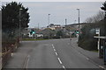
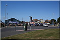
2
Junction of Radipole Lane and Chickerell Road, Weymouth
Image: © Roger Cornfoot
Taken: 2 Apr 2009
0.19 miles
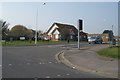
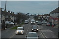
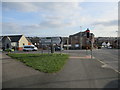
5
Fiveways Junction
Fiveways junction on Chickerell Road.
Image: © John Stephen
Taken: 29 Jul 2014
0.19 miles
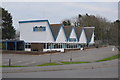
8
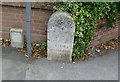
Old Boundary Marker by the B3165, Lanehouse Rocks Road, Weymouth
Parish Boundary Marker by the B3156, in parish of Weymouth (Weymouth and Portland District), Lanehouse Rocks Road, South of junction with Chickerell Road, against wall, West side of road.
Inscription reads:-
BOROUGH
OF
WEYMOUTH
AND
MELCOMBE
REGIS
1933
HAMBLIN
MAYOR
Surveyed
Milestone Society National ID: DO_WM04pb
Image: © Milestone Society
Taken: Unknown
0.19 miles

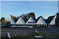
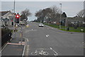
10
Fiveways Junction
The Curtis Fields development is on the far side of Chickerell Road on the left of centre. See views prior to Curtis Fields development Image, Image and Image
Image: © John Stephen
Taken: 20 Mar 2018
0.20 miles