IMAGES TAKEN NEAR TO
Essex Road, WEYMOUTH, DT4 0BA
Introduction
This page details the photographs taken nearby to Essex Road, DT4 0BA by members of the Geograph project.
The Geograph project started in 2005 with the aim of publishing, organising and preserving representative images for every square kilometre of Great Britain, Ireland and the Isle of Man.

There are currently over 7.5m images from over14,400 individuals and you can help contribute to the project by visiting https://www.geograph.org.uk
Image Map (Loading...)


Getting Data...Please wait
Leaflet Map data © OpenStreetMap
Images are licensed for reuse under creativecommons.org/licenses/by-sa/2.0
Notes
- Clicking on the map will re-center to the selected point.
- The higher the marker number, the further away the image location is from the centre of the postcode.
Image Listing (134 Images Found)
Images are licensed for reuse under creativecommons.org/licenses/by-sa/2.0
Image
Details
Distance
3
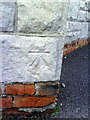
Benchmark on St Paul's Church
Ordnance Survey cut mark benchmark described on the Bench Mark Database at http://www.bench-marks.org.uk/bm36354
Image: © Roger Templeman
Taken: 23 Dec 2010
0.05 miles
4
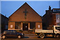
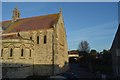
St. Paul's church, Abbotsbury Road, Weymouth
The church is described on its website as "a lively, forward-looking Anglican church in the catholic tradition under the care of the Bishop of Ebbsfleet (Options A, B and C)".
Image: © Jonathan Billinger
Taken: 20 May 2009
0.05 miles
6
Benchmark on The Rock public house
Ordnance Survey cut mark benchmark described on the Bench Mark Database at http://www.bench-marks.org.uk/bm36355
Image: © Roger Templeman
Taken: 23 Dec 2010
0.06 miles
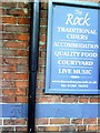
8
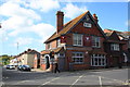
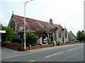
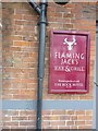
Flaming Jack's at The Rock Hotel
The Rock Hotel had a revamp in February and is now "Flaming Jack's bar and grill.
Built in 1881 as a tavern, in the corner of a field known as 'Rocks Close'. The Rock is the first and oldest pub in Westham. The original building much of which has survived was commissioned by John Groves & Sons Ltd of Hope Brewery, Hope Square, Weymouth. The gable end has JG under the eaves and the remains of the brewer's painted name sign can be seen on the front wall above the ground floor window. Being the only public house in the area it became a focal point for the rapidly expanding community. A general meeting was convened at the pub in 1882 in order to agree a name for the area which was being built up around the pub. The name decided on was West Ham, now shortened to Westham (West'am, to the locals).
As an aside, John Groves also opened pubs in Swindon to cater for trade from the workers from the GWR workshops, notably the Queens Tap opposite Swindon Station and the Glue Pot in the Railway Village. The works had Trip Week in July when it shut down for a week and special workers trains were run to Weymouth and other resorts. Groves was eventually taken over by Devenish. The Weymouth line had a separate platform on Swindon Station until the demise of trip week and a redevelopment in the 1970s.
Image: © John Stephen
Taken: 20 May 2015
0.06 miles
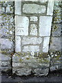
9
Benchmark on The Rock Hotel (Flaming Jack's), Weymouth
Ordnance Survey benchmark, described on database at http://www.bench-marks.org.uk/bm36355. The paintwork and name has changed since Roger Templeman's visit in 2010. See http://www.geograph.org.uk/photo/2223320.
Image: © Becky Williamson
Taken: 6 Jul 2015
0.06 miles
10
Benchmark on cemetery wall pier of Newstead Road
Ordnance Survey cut mark benchmark described on the Bench Mark Database at http://www.bench-marks.org.uk/bm36391
Image: © Roger Templeman
Taken: 23 Dec 2010
0.07 miles