Flaming Jack's at The Rock Hotel
Introduction
The photograph on this page of Flaming Jack's at The Rock Hotel by John Stephen as part of the Geograph project.
The Geograph project started in 2005 with the aim of publishing, organising and preserving representative images for every square kilometre of Great Britain, Ireland and the Isle of Man.

There are currently over 7.5m images from over 14,400 individuals and you can help contribute to the project by visiting https://www.geograph.org.uk
Flaming Jack's at The Rock Hotel
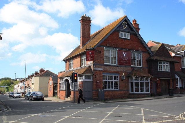
Image: © John Stephen Taken: 20 May 2015
The Rock Hotel had a revamp in February and is now "Flaming Jack's bar and grill. Built in 1881 as a tavern, in the corner of a field known as 'Rocks Close'. The Rock is the first and oldest pub in Westham. The original building much of which has survived was commissioned by John Groves & Sons Ltd of Hope Brewery, Hope Square, Weymouth. The gable end has JG under the eaves and the remains of the brewer's painted name sign can be seen on the front wall above the ground floor window. Being the only public house in the area it became a focal point for the rapidly expanding community. A general meeting was convened at the pub in 1882 in order to agree a name for the area which was being built up around the pub. The name decided on was West Ham, now shortened to Westham (West'am, to the locals). As an aside, John Groves also opened pubs in Swindon to cater for trade from the workers from the GWR workshops, notably the Queens Tap opposite Swindon Station and the Glue Pot in the Railway Village. The works had Trip Week in July when it shut down for a week and special workers trains were run to Weymouth and other resorts. Groves was eventually taken over by Devenish. The Weymouth line had a separate platform on Swindon Station until the demise of trip week and a redevelopment in the 1970s.
Images are licensed for reuse under creativecommons.org/licenses/by-sa/2.0
Image Location


Leaflet Map data © OpenStreetMap
Latitude
50.61168
Longitude
-2.463374