IMAGES TAKEN NEAR TO
Millers Close, WEYMOUTH, DT3 6RL
Introduction
This page details the photographs taken nearby to Millers Close, DT3 6RL by members of the Geograph project.
The Geograph project started in 2005 with the aim of publishing, organising and preserving representative images for every square kilometre of Great Britain, Ireland and the Isle of Man.

There are currently over 7.5m images from over14,400 individuals and you can help contribute to the project by visiting https://www.geograph.org.uk
Image Map
Images are licensed for reuse under creativecommons.org/licenses/by-sa/2.0
Notes
- Clicking on the map will re-center to the selected point.
- The higher the marker number, the further away the image location is from the centre of the postcode.
Image Listing (48 Images Found)
Images are licensed for reuse under creativecommons.org/licenses/by-sa/2.0
Image
Details
Distance
1

Willowbank Farm, home of Weymouth beach donkeys
Image: © Alex McGregor
Taken: 3 Sep 2011
0.06 miles
2
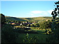
Sutton Poyntz
View of the village and surrounding hills
Image: © Steve Cook
Taken: 19 Aug 2005
0.08 miles
3
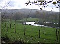
The River Jordan
The one flowing through Preston of course. This is a popular walk between Preston and Sutton Poyntz. On a very blustery day I was lucky with the weather, but two minutes after taking this photo the hail stones struck. Where is the shelter? Exactly.
Image: © Graham Horn
Taken: 19 Nov 2007
0.08 miles
4
Statue of Seven Acres
A small landmark within Preston, Weymouth
Image: © Tom Pocock
Taken: 11 Jul 2019
0.09 miles

7
![Preston features [3]](https://s1.geograph.org.uk/geophotos/07/25/95/7259585_26a94f2f_120x120.jpg)
Preston features [3]
The River Jordan, seen from the footbridge alongside Riverside House Image
Preston is a coastal village, a suburb of Weymouth in Dorset, some 3 miles northeast of Weymouth town centre. The village has a long history of settlement, with the remains of a Roman temple and a Stone Age hill fort, Chalbury Camp. Preston has strong links with the Wesley family, the founders of Methodism. South of the village, towards the shore, are a number of highly unattractive holiday parks.
Image: © Michael Dibb
Taken: 1 Jun 2022
0.15 miles
8
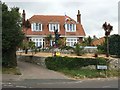
![Preston houses [1]](https://s2.geograph.org.uk/geophotos/07/25/95/7259586_37110ab7_120x120.jpg)
Preston houses [1]
Riverside House, seen from the adjacent footbridge over the River Jordan. Built in the late 18th or early 19th century. Constructed of painted, coursed rubble stone under a slate roof. Listed, grade II, with details at: https://historicengland.org.uk/listing/the-list/list-entry/1135189
Preston is a coastal village, a suburb of Weymouth in Dorset, some 3 miles northeast of Weymouth town centre. The village has a long history of settlement, with the remains of a Roman temple and a Stone Age hill fort, Chalbury Camp. Preston has strong links with the Wesley family, the founders of Methodism. South of the village, towards the shore, are a number of highly unattractive holiday parks.
Image: © Michael Dibb
Taken: 1 Jun 2022
0.15 miles
9
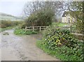
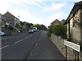
Lane out of Preston
A footpath leaves Preston to the north-west. This is the last house before the open countryside and the footpath is very popular with dog walkers.
Image: © Graham Horn
Taken: 19 Nov 2007
0.15 miles
10
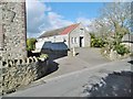
Sutton Poyntz, disused church
On Sutton Road. The building shows no notice board, but a road sign at the top of the road points to "Evangelical Church", so presumably this is it?
Image: © Mike Faherty
Taken: 21 Feb 2015
0.15 miles