IMAGES TAKEN NEAR TO
Mount Pleasant Avenue North, WEYMOUTH, DT3 5HW
Introduction
This page details the photographs taken nearby to Mount Pleasant Avenue North, DT3 5HW by members of the Geograph project.
The Geograph project started in 2005 with the aim of publishing, organising and preserving representative images for every square kilometre of Great Britain, Ireland and the Isle of Man.

There are currently over 7.5m images from over14,400 individuals and you can help contribute to the project by visiting https://www.geograph.org.uk
Image Map
Images are licensed for reuse under creativecommons.org/licenses/by-sa/2.0
Notes
- Clicking on the map will re-center to the selected point.
- The higher the marker number, the further away the image location is from the centre of the postcode.
Image Listing (44 Images Found)
Images are licensed for reuse under creativecommons.org/licenses/by-sa/2.0
Image
Details
Distance
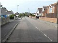
3
Dorchester Road, June 1984
In 1984 the old house on the right was being demolished in preparation for the building of the link road. The entrance to Mount Pleasant Avenue is on the left and Greenway Road,in the distance, on the right. This is now the site of the link road roundabout. Here is another view from the North.Image
Image: © Gordon Cragg
Taken: Unknown
0.06 miles
5
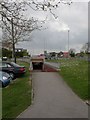
Radipole, subway
Enabling pedestrians to negotiate the Dorchester Road/Weymouth Way roundabout.
Image: © Mike Faherty
Taken: 16 Apr 2011
0.06 miles

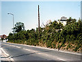
7
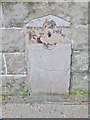
Old Milestone by the A354, Radipole
Stone post (plate lost) by the A354, in Borough of Weymouth (Weymouth and Portland District), Dorchester Road, set into wall of "Hazelhead", 309 Dorchester Road, on West side of road. Dorset 1 and 4 (iron plated), erected by the Weymouth, Melcombe Regis & Dorchester Turnpike Trust in the 19th century.
Inscription once read:-
6
Dorchester
Weymouth
2
Carved benchmark bottom right of front face.
Milestone Society National ID: DO_DOWM06.
Image: © Milestone Society
Taken: 24 Apr 2017
0.08 miles
8
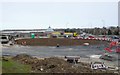
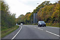
Weymouth Relief Road March 2010
View south across the roundabout in state of construction at the southern access point to the new road on the Dorchester Road.The new road will come in on the left, the Dorchester Rd heading towards the coast is straight ahead and the Weymouth Way goes off to the right. The photo was taken from the southern end of Greenway Rd
Image: © Nigel Mykura
Taken: 22 Mar 2010
0.09 miles
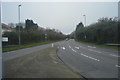
9
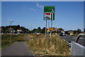
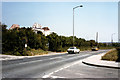
Manor Roundabout, Weymouth
After approaching Weymouth along the relief road this is where normality resumes. The A 354 used to run left to right along Dorchester Road through Broadwey, Upwey and the notorious U-bend at Lower Bincombe.
Image: © John Stephen
Taken: 29 Jul 2014
0.09 miles
10
Dorchester Road, June 1984
Dorchester Road looking South-eastward from the corner of Manor Road. This is now the site of the link road roundabout. Another view from the South Image
Image: © Gordon Cragg
Taken: Unknown
0.09 miles