IMAGES TAKEN NEAR TO
Ullswater Crescent, WEYMOUTH, DT3 5HF
Introduction
This page details the photographs taken nearby to Ullswater Crescent, DT3 5HF by members of the Geograph project.
The Geograph project started in 2005 with the aim of publishing, organising and preserving representative images for every square kilometre of Great Britain, Ireland and the Isle of Man.

There are currently over 7.5m images from over14,400 individuals and you can help contribute to the project by visiting https://www.geograph.org.uk
Image Map
Images are licensed for reuse under creativecommons.org/licenses/by-sa/2.0
Notes
- Clicking on the map will re-center to the selected point.
- The higher the marker number, the further away the image location is from the centre of the postcode.
Image Listing (21 Images Found)
Images are licensed for reuse under creativecommons.org/licenses/by-sa/2.0
Image
Details
Distance
1

Bridge over A354 Weymouth Way
Spa Road crosses.
Image: © Robin Webster
Taken: 3 Nov 2018
0.08 miles
2
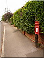
Radipole: postbox № DT4 46, Spa Road
This postbox is a bit of a misnomer since it is fairly comfortably in the DT3 postal district but has a DT4 number. It may be that it is on a DT4 collection round.
The box is strapped to a wooden post and is emptied finally at 5:15pm on weekdays and at noon on Saturdays.
Image: © Chris Downer
Taken: 30 May 2010
0.10 miles
3
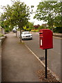
Radipole: postbox № DT3 87, Ullswater Crescent
This small postbox is emptied finally at 5:15pm on weekdays and at noon on Saturdays.
Image: © Chris Downer
Taken: 30 May 2010
0.11 miles
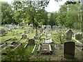
5
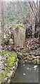
The Ancient Altar and School Room
The stone altar lies in the grounds of St. Ann's Church, Radipole. The church, lying off the image to the left, dates from c 1250 and as such is believed to be the oldest building in Weymouth.
Image: © Ivan Hall
Taken: 3 Sep 2009
0.12 miles
6
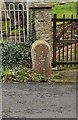
Old Boundary Marker behind the old school on Radipole Lane
Municipal Boundary Marker in the eastern corner of the car park next to the old school on the southeast side of Radipole Lane, opposite St Anne's church. Inscribed BOROUGH/ OF / WEYMOUTH / AND / MELCOMBE / REGIS / 1895 / T H WILLIAMS / MAYOR and marking the boundary of the former municipal borough.
Milestone Society National ID: DO_WM15pb
Image: © D Dougherty
Taken: 21 Feb 2021
0.13 miles
8
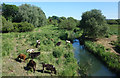
Cows by the River Wey
Downstream from here the Wey valley widens out into an area of reedbeds, lakes and wetland which is the Radipole Lake Nature Reserve.
Image: © Des Blenkinsopp
Taken: 3 Jun 2018
0.13 miles
9
Old Boundary Marker on Radipole Lane
Municipal Boundary Marker in front of the gatepost to the old school on the southeast side of Radipole Lane, opposite St Anne's church. Inscribed BOROUGH/ OF / WEYMOUTH / AND / MELCOMBE / REGIS / 1895 / T H WILLIAMS / MAYOR and marking the boundary of the former municipal borough.
Milestone Society National ID: DO_WM14pb
Image: © D Dougherty
Taken: 21 Feb 2021
0.14 miles
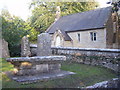
10
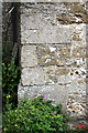
Benchmark on porch of St Ann's Church
Ordnance Survey cut mark benchmark described on the Bench Mark Database at http://www.bench-marks.org.uk/bm51605
Image: © Roger Templeman
Taken: 21 Sep 2013
0.15 miles