IMAGES TAKEN NEAR TO
Gorwell, WEYMOUTH, DT3 4JX
Introduction
This page details the photographs taken nearby to Gorwell, DT3 4JX by members of the Geograph project.
The Geograph project started in 2005 with the aim of publishing, organising and preserving representative images for every square kilometre of Great Britain, Ireland and the Isle of Man.

There are currently over 7.5m images from over14,400 individuals and you can help contribute to the project by visiting https://www.geograph.org.uk
Image Map
Images are licensed for reuse under creativecommons.org/licenses/by-sa/2.0
Notes
- Clicking on the map will re-center to the selected point.
- The higher the marker number, the further away the image location is from the centre of the postcode.
Image Listing (10 Images Found)
Images are licensed for reuse under creativecommons.org/licenses/by-sa/2.0
Image
Details
Distance
1
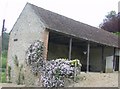
Barn at Gorwell Farm
Mainly used for vehicle parking it would appear.
Image: © Graham Horn
Taken: 7 May 2007
0.01 miles
2
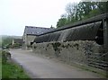
Gorwell Farm
Back in stone-built territory. But there the stone is very irregular and held together with a lot of mortar. Gorwell Farm appears to have a number of holiday cottages to let (no I am not the owner!) as well as being a working farm.
Image: © Graham Horn
Taken: 7 May 2007
0.03 miles
3
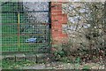
Benchmark on building at Gorwell Farm
Ordnance Survey benchmark, described on database at http://www.bench-marks.org.uk/bm81290.
Image: © Becky Williamson
Taken: 18 Dec 2016
0.04 miles
4
Gorwell Farm on the South Dorset Ridgeway
Image: © Becky Williamson
Taken: 3 Sep 2016
0.12 miles
5

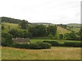
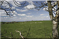
Descent to Gorwell Farm
In Dorset, what comes down must go up. So down from one ridge, and another appears ahead, despite being only two miles from the sea.
Image: © Graham Horn
Taken: 7 May 2007
0.12 miles
6
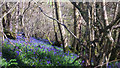
Bluebells in Broad Coppice, near Abbotsbury
A beautiful private woodland where I attended a wildflowers in ancient woodland identification course.
Image: © Becky Williamson
Taken: 23 Apr 2016
0.13 miles
7
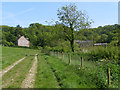
Approaching Gorwell Farm from the north
On the right are the buildings of Gorwell Farm, on the left cottages in this remote location (over a mile away from the nearest public road). A bridleway runs up the coombe through the farm and the coppices beyond.
Image: © Jim Champion
Taken: 1 Jun 2006
0.13 miles
8
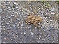
Toad saved
We just avoided stepping on this creature, blending in well with the road surface. We persuaded him to wander off into a ditch. So more services to animal welfare provided, mirroring those near the beginning of the Macmillan Way 273 miles earlier. See: Image]
Image: © Graham Horn
Taken: 7 May 2007
0.16 miles
9
Kingston Russell stone circle
Kingston Russell stone circle lies on the uplands to the south east of the Bride Valley above Ashley Chase. This shot was taken looking west towards Golden Cap which is just visible in the centre, just below the horizon. The far coastline is that of East Devon, some 17 miles away.
Image: © BrideValley
Taken: 9 Apr 2005
0.24 miles
10
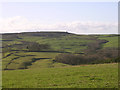
View southwest from the Kingston Russell stone circle towards Abbotsbury Castle
Everything in the lower half of the photo is in the grid square. Beyond that are the many coppices in grid squares SY5686 and SY5687. In the middle on the horizon are the ramparts of the Abbotsbury iron age hillfort - the large bowl barrow in its interior and the defences at its SE end (on the left) are quite obvious against the sky even from this distance.
Image: © Jim Champion
Taken: 26 Dec 2004
0.24 miles