IMAGES TAKEN NEAR TO
Friar Waddon, WEYMOUTH, DT3 4EW
Introduction
This page details the photographs taken nearby to DT3 4EW by members of the Geograph project.
The Geograph project started in 2005 with the aim of publishing, organising and preserving representative images for every square kilometre of Great Britain, Ireland and the Isle of Man.

There are currently over 7.5m images from over14,400 individuals and you can help contribute to the project by visiting https://www.geograph.org.uk
Image Map (Loading...)


Getting Data...Please wait
Leaflet Map data © OpenStreetMap
Images are licensed for reuse under creativecommons.org/licenses/by-sa/2.0
Notes
- Clicking on the map will re-center to the selected point.
- The higher the marker number, the further away the image location is from the centre of the postcode.
Image Listing (5 Images Found)
Images are licensed for reuse under creativecommons.org/licenses/by-sa/2.0
Image
Details
Distance
1
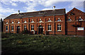
Friar Waddon Pumping Station
This is the water supply pumping station for the Isle of Portland in Dorset. Dates from 1912 and has a disused diesel engine driving an Ashley concertina pump. Now all electric. The hatches in the roof allow a large road crane to lift the bore hole pumps straight out. Expensive but quick.
A real gem hidden down the lanes on the escarpment.
Image: © Chris Allen
Taken: 25 Sep 2005
0.03 miles
2

Friar Waddon Pumping Station
This is the retained diesel engine pumping set with a Ruston horizontal single cylinder driving a two cylinder reciprocating double-acting force pump and an Ashley concertina well pump.
Image: © Chris Allen
Taken: 25 Sep 2005
0.03 miles
3
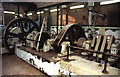
Friar Waddon Pumping Station
The diesel driven pump set. The engine and flywheel are in the left background. The cranks for the "concertina" pump are on the right and in the middle are the clutch and reduction gear drive to said pump.
Image: © Chris Allen
Taken: 25 Sep 2005
0.07 miles
4
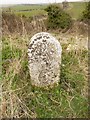
Old Boundary Marker east of Friar Waddon, Weymouth Parish
Parish Boundary Marker by the UC road, in parish of Weymouth (Weymouth And Portland District), Friar Waddon, next to disused quarry on verge.
Surveyed
Milestone Society National ID: DO_WM06pb
Image: © Milestone Society
Taken: Unknown
0.18 miles
5
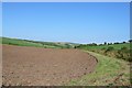
Friar Waddon
Friar Waddon lies in a dry chalk valley parallel to the Ridgeway. This is the view along the valley east towards Upwey
Image: © Nigel Mykura
Taken: 26 Jul 2008
0.22 miles