IMAGES TAKEN NEAR TO
Cerne Villa Park, Chickerell Road, WEYMOUTH, DT3 4AB
Introduction
This page details the photographs taken nearby to Cerne Villa Park, Chickerell Road, DT3 4AB by members of the Geograph project.
The Geograph project started in 2005 with the aim of publishing, organising and preserving representative images for every square kilometre of Great Britain, Ireland and the Isle of Man.

There are currently over 7.5m images from over14,400 individuals and you can help contribute to the project by visiting https://www.geograph.org.uk
Image Map (Loading...)


Getting Data...Please wait
Leaflet Map data © OpenStreetMap
Images are licensed for reuse under creativecommons.org/licenses/by-sa/2.0
Notes
- Clicking on the map will re-center to the selected point.
- The higher the marker number, the further away the image location is from the centre of the postcode.
Image Listing (31 Images Found)
Images are licensed for reuse under creativecommons.org/licenses/by-sa/2.0
Image
Details
Distance
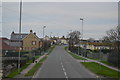
1
Charlestown, park homes
Cerne Villa Park, off Chickerell Road: https://www.wyldecrestparks.co.uk/property_location/cerne-villa-park/
Image: © Mike Faherty
Taken: 14 Apr 2018
0.05 miles
2
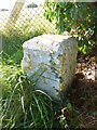
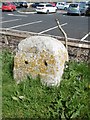
Old Boundary Marker by the B3156, Chickerell Road, Charlestown
Estate Boundary Marker - War Department by the B3156, in parish of Chickerell (West Dorset District), Chickerell Road, at right hand side of entrance to training area, against railings opposite park homes.
Surveyed
Milestone Society National ID: DO_WDCHI08em
Image: © Mike Faherty
Taken: 23 Oct 2013
0.06 miles
4
Old Milestone by the B3157, Chickerell Road, Charlestown
Stone post (plate lost) by the B3157, in parish of Chickerell (West Dorset District), just South of junction with Australia Road in front of Aldi store, on the verge, on North-east side of road, next to cable box. Erected by the Abbotsbury & Bridport Turnpike Trust in the 19th century.
The missing plate once read:-
(Weymouth Bridge 2)
Milestone Society National ID: DO_WMAB02.
Image: © Milestone Society
Taken: 14 Apr 2018
0.11 miles
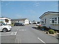
5
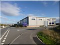
Charlestown, Link Park
Business Park off Hampshire Road.
Image: © Mike Faherty
Taken: 23 Oct 2013
0.11 miles
6
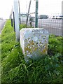
Old Boundary Marker by Australia Road, Chickerell parish
Estate Boundary Marker - War Department by Australia Road, off the B3156, Chickerell Road, in parish of Chickerell (West Dorset District). Southeast corner of camp entrance, against railings.
Surveyed
Milestone Society National ID: DO_WDCHI02em
Image: © Mike Faherty
Taken: 23 Oct 2013
0.12 miles
7
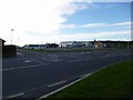
Chickerell Training Camp
MoD site fronting onto Chickerell Road.
Image: © Mike Faherty
Taken: 23 Oct 2013
0.12 miles
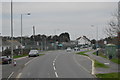
8
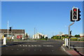
Traffic lights on road junction at Chickerell
These lights are on the junction of the B3157 and the new road through to the Granby Industrial estate, which does not yet appear on the OS maps of the area.
Image: © Stephen Williams
Taken: 23 May 2007
0.13 miles
9
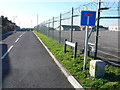
Australia Rd, Chickerell, Weymouth
Australia Rd runs alongside a TA Camp on the Chickerell Rd just W of Weymouth. There is a boundary stone in the right foreground marked WD with a broad arrow head and the number 2
Image: © Nigel Mykura
Taken: 30 Jan 2008
0.13 miles