IMAGES TAKEN NEAR TO
Church View, DORCHESTER, DT2 9WD
Introduction
This page details the photographs taken nearby to Church View, DT2 9WD by members of the Geograph project.
The Geograph project started in 2005 with the aim of publishing, organising and preserving representative images for every square kilometre of Great Britain, Ireland and the Isle of Man.

There are currently over 7.5m images from over14,400 individuals and you can help contribute to the project by visiting https://www.geograph.org.uk
Image Map
Images are licensed for reuse under creativecommons.org/licenses/by-sa/2.0
Notes
- Clicking on the map will re-center to the selected point.
- The higher the marker number, the further away the image location is from the centre of the postcode.
Image Listing (67 Images Found)
Images are licensed for reuse under creativecommons.org/licenses/by-sa/2.0
Image
Details
Distance
1
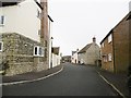
Stratton, Meadow Bottom
Like most of the housing in this corner of the village, modern; but showing sympathetic use of vernacular cladding (thatch or stone and flint).
Image: © Mike Faherty
Taken: 3 Nov 2015
0.05 miles

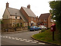
3
Stratton, postbox
DT2 605, at the western end of the village, on Dorchester Road; ahead, A37 and the village by-pass.
Image: © Mike Faherty
Taken: 3 Nov 2015
0.09 miles
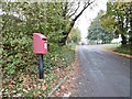
4
Stratton: postbox № DT2 605
This modern postbox is at the western extremity of Stratton village, with its back to a small new housing development. Items need to be in the box by 9am, Monday to Saturday, in order to catch that day's post.
Image: © Chris Downer
Taken: 7 Jun 2009
0.09 miles
5
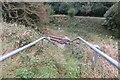
Crossing the railway line near Grimstone
This is the Wessex line.
Image: © Becky Williamson
Taken: 8 Oct 2016
0.10 miles
6
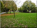
Stratton Village Green
Overlooking Dorchester Road; with seats and a playground (out of sight).
Image: © Mike Faherty
Taken: 3 Nov 2015
0.12 miles
7
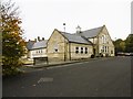
Stratton Village Hall
On the Square; dated 2000.
Image: © Mike Faherty
Taken: 3 Nov 2015
0.12 miles
8
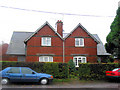
Houses in Stratton
This pair of red brick houses (and another pair out of picture to the right) were built by the local farmer for his workers. The farm was a little way down a track on the opposite side of the road almost facing the houses but a little way to the right. The farm buildings have relocated and in their place there is new housing around a small village green went up around 2000. There is also a new pub (The Saxon Arms) which has a reputation for good food, the village's previous pub having been converted into flats a few years previously, and a new village hall. The village has increased in size somewhat over the past couple decades or so.
Image: © David Ward
Taken: 2 Nov 2002
0.13 miles
9
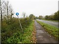
Stratton, footpath
Alongside Dorchester Road (A37); the wonky sign indicates that the path is to be shared by pedestrians and cyclists.
Image: © Mike Faherty
Taken: 3 Nov 2015
0.13 miles
10
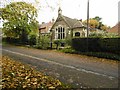
Stratton, former school
On Dorchester Road, dated 1898; now residential.
Image: © Mike Faherty
Taken: 3 Nov 2015
0.13 miles