IMAGES TAKEN NEAR TO
Westleaze, DORCHESTER, DT2 9PZ
Introduction
This page details the photographs taken nearby to Westleaze, DT2 9PZ by members of the Geograph project.
The Geograph project started in 2005 with the aim of publishing, organising and preserving representative images for every square kilometre of Great Britain, Ireland and the Isle of Man.

There are currently over 7.5m images from over14,400 individuals and you can help contribute to the project by visiting https://www.geograph.org.uk
Image Map (Loading...)


Getting Data...Please wait
Leaflet Map data © OpenStreetMap
Images are licensed for reuse under creativecommons.org/licenses/by-sa/2.0
Notes
- Clicking on the map will re-center to the selected point.
- The higher the marker number, the further away the image location is from the centre of the postcode.
Image Listing (12 Images Found)
Images are licensed for reuse under creativecommons.org/licenses/by-sa/2.0
Image
Details
Distance
1
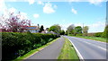
Charminster old Dorchester road.
This used to be the main road from Charminster to Dorchester when the main roads kept to higher ground to avoid marshy land on the flood plain of the River Frome. A new road was built centuries ago on a raised causeway across the meadows and it became the A37 running south of the village. This is now the C12 to Sherborne, straight , fast and notorious for road deaths.
Image: © Nigel Mykura
Taken: 2 May 2008
0.03 miles
2
Farm Track , Charminster
This track leads off the Charminster to Burton road in the direction of Higher Burton Farm
Image: © Nigel Mykura
Taken: 2 May 2008
0.07 miles
3
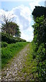
One woman and her Dog
We were overtaken by this woman and her dog on the footpath between Lower Burton and Charminster. The field had been recently ploughed and seeded and the footpath runs in one of the tractor ruts. The small building is a sewage pumping station.
Image: © Nigel Mykura
Taken: 17 Mar 2012
0.17 miles
4
Milestone between Burton and Charminster
Also seen in Image and obviously restored since that picture was taken
Image: © David Smith
Taken: 26 Aug 2020
0.18 miles
5
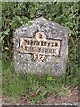
Old Milestone by Westleaze, north of Burton
Metal plate attached to stone post by the UC road, in parish of CHARMINSTER (WEST DORSET District), Burton, 400m from 'The Sun Inn', leaving Burton to the north, on West side of road. Dorset 1 and 4 (iron plated), erected by the Weymouth, Melcombe Regis & Dorchester turnpike trust in the 19th century.
Inscription reads:-
1
DORCHESTER
SHERBORNE
17
Milestone Society National ID: DO_DOSB01
Image: © Mike Faherty
Taken: 7 Aug 2010
0.19 miles
6
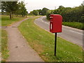
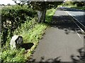
Charminster: postbox № DT2 500, Westleaze
A small postbox serving the eastern extremities of Charminster; it is emptied daily except Sundays at 9am.
Image: © Chris Downer
Taken: 7 Jun 2009
0.19 miles
7
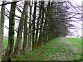
Line of trees.
these trees had been very closely planted together along the footpath from Lower Burton to Charminster. We eyed them up as a potentially excellent bovine barrier if the bull in the field became too interested in us.
Image: © Nigel Mykura
Taken: 17 Mar 2012
0.21 miles
8
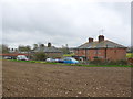
Cottages Lower Burton Farm
The farms in this area are owned by Ilchester Estates and these were originally estate cottages. They may still be.
Image: © Nigel Mykura
Taken: 17 Mar 2012
0.23 miles
9
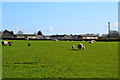
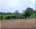
Field and houses in Charminster
Houses on Westleaze, seen from a footpath fromCharminster to Burton.
Image: © Peter Barr
Taken: 30 Apr 2013
0.23 miles
10
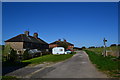
Cottages at Lower Burton Farm
On the road from Dorchester to Westleaze. Caravan and footpath signpost.
Image: © Peter Barr
Taken: 30 Apr 2013
0.24 miles