IMAGES TAKEN NEAR TO
Long Bredy, DORCHESTER, DT2 9AA
Introduction
This page details the photographs taken nearby to DT2 9AA by members of the Geograph project.
The Geograph project started in 2005 with the aim of publishing, organising and preserving representative images for every square kilometre of Great Britain, Ireland and the Isle of Man.

There are currently over 7.5m images from over14,400 individuals and you can help contribute to the project by visiting https://www.geograph.org.uk
Image Map
Images are licensed for reuse under creativecommons.org/licenses/by-sa/2.0
Notes
- Clicking on the map will re-center to the selected point.
- The higher the marker number, the further away the image location is from the centre of the postcode.
Image Listing (18 Images Found)
Images are licensed for reuse under creativecommons.org/licenses/by-sa/2.0
Image
Details
Distance
1
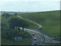
Countryside near Kingston Russell
Looking SW from the eastern edge grid square, south of the A35
Image: © Nigel Mykura
Taken: 17 Sep 2008
0.01 miles
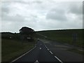
2

The A35 at Kingston Russell
Looking west at the start of the dual carriageway from just inside the eastern edge of the grid square.
Image: © Nigel Mykura
Taken: 17 Sep 2008
0.12 miles
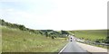
3

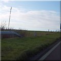
Westbound A35
About 2.5 km of dual carriageway across the summit of the route.
Image: © Robin Webster
Taken: 18 Jul 2019
0.12 miles
4
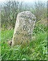
Old Milestone by the A35, Long Bredy, west of Dorchester
Carved stone post by the A35, in parish of Long Bredy (West Dorset District), 250m West of Litton Cheney turning, 2m back from road at end of crash barrier, on South side of road. Dorset 1 (limestone), erected by the Harnham, Blandford & Dorchester Turnpike Trust in the 19th century.
Inscription reads:-
Dorchester
8
Bridport
7
Milestone Society National ID: DO_BPDO07.
Image: © Milestone Society
Taken: 31 Mar 2017
0.13 miles
5
Milestone beside the A35 dual carriageway
According to the 19th century map, it reads: Bridport 7, Dorchester 8
Image: © David Smith
Taken: 27 Dec 2013
0.13 miles
8
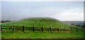
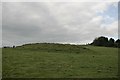
Tumulus by the A35
One of a number of tumuli in the area.
Image: © N Chadwick
Taken: 28 Dec 2011
0.16 miles
9
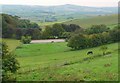
A35 junction at Long Breedy Hut
The dip in the road is a convenient meeting point for roads approaching from several directions
Image: © David Smith
Taken: 8 Jul 2019
0.16 miles