IMAGES TAKEN NEAR TO
Woodbury Drove, DORCHESTER, DT2 8XT
Introduction
This page details the photographs taken nearby to Woodbury Drove, DT2 8XT by members of the Geograph project.
The Geograph project started in 2005 with the aim of publishing, organising and preserving representative images for every square kilometre of Great Britain, Ireland and the Isle of Man.

There are currently over 7.5m images from over14,400 individuals and you can help contribute to the project by visiting https://www.geograph.org.uk
Image Map
Images are licensed for reuse under creativecommons.org/licenses/by-sa/2.0
Notes
- Clicking on the map will re-center to the selected point.
- The higher the marker number, the further away the image location is from the centre of the postcode.
Image Listing (13 Images Found)
Images are licensed for reuse under creativecommons.org/licenses/by-sa/2.0
Image
Details
Distance
1
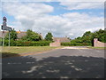
Crossways: western end of Dick o? th? Banks Road
The signpost points towards Dick o' th' Banks 'access only' but those last two words serve merely to discourage through traffic. There is no physical barrier to motorists making a through journey down there.
Image: © Chris Downer
Taken: 20 Jun 2009
0.09 miles
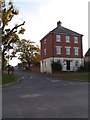
3

Crossways: postbox № DT2 189 and phone, Paul?s Way
A small postbox serving the modern western end of this fairly young village.
Image: © Chris Downer
Taken: 27 Dec 2008
0.11 miles

5

WWII Dorset: discovering RAF Warmwell (17)
-
The Airfield - LAA emplacement EDoB ID: e47785
Close-up of the 'Motley stalk' machine gun mount. Typically used to mount twin Browning machine guns for use in a light anti-aircraft role.
Image
Image: © Mike Searle
Taken: 10 Jan 2020
0.14 miles
6

WWII Dorset: discovering RAF Warmwell (18)
-
The Airfield - LAA emplacement EDoB ID: e47785
Contextual view of the gun pit.
Image
Image: © Mike Searle
Taken: 10 Jan 2020
0.14 miles
7

WWII Dorset: discovering RAF Warmwell (16)
-
The Airfield - LAA emplacement EDoB ID: e47785
The 'Motley stalk' gun mount has been revealed by clearing away the vegetation that had previously obscured it.
Image
Image: © Mike Searle
Taken: 10 Jan 2020
0.14 miles
8
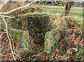
WWII Dorset: discovering RAF Warmwell (15)
-
The Airfield - LAA emplacement EDoB ID: e47785
This circular brick-built gun pit was probably one of several that were built for light anti-aircraft defence of the airfield. It lies on the north side of the road within the hedgeline, about 100 yards east of Egdon House. The recess to the rear was probably to house an ammunition locker. Not quite visible in this photo in the centre of the gun pit, is a tubular machine gun mounting called a 'Motley stalk'.
Image
Image: © Mike Searle
Taken: 10 Jan 2020
0.15 miles
9
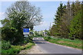
Level Crossing
This is looking north across the crossing at Higher Woodsford
Image: © Nigel Mykura
Taken: 11 May 2008
0.16 miles
10

Level Crossing at Higher Woodsford
Looking northwest in the direction of Woodsford. The sheds beyond belong to the Dairy Centre at Higher Woodsford.
Image: © Mike Searle
Taken: 21 Mar 2007
0.19 miles