IMAGES TAKEN NEAR TO
Orford Mews, DORCHESTER, DT2 8UG
Introduction
This page details the photographs taken nearby to Orford Mews, DT2 8UG by members of the Geograph project.
The Geograph project started in 2005 with the aim of publishing, organising and preserving representative images for every square kilometre of Great Britain, Ireland and the Isle of Man.

There are currently over 7.5m images from over14,400 individuals and you can help contribute to the project by visiting https://www.geograph.org.uk
Image Map
Images are licensed for reuse under creativecommons.org/licenses/by-sa/2.0
Notes
- Clicking on the map will re-center to the selected point.
- The higher the marker number, the further away the image location is from the centre of the postcode.
Image Listing (170 Images Found)
Images are licensed for reuse under creativecommons.org/licenses/by-sa/2.0
Image
Details
Distance
1
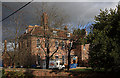
Dawnay House - Puddletown
A view from the churchyard of what was the west wing of The Old Vicarage that was added to the older building in 1722. The older part (seen just behind the west wing) originally of circa 1600, was significantly altered probably in the C18 and early C19. The whole now forms two separate semi-detached properties, the west wing being Dawnay House, built for Dr. Henry Dawnay, who was vicar at Puddletown from 1722 to 1754. Grade II* Listed.
Image: © Mike Searle
Taken: 3 Dec 2007
0.05 miles
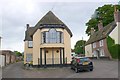
2
![Puddletown houses [14]](https://s2.geograph.org.uk/geophotos/06/77/34/6773434_1ae02783_120x120.jpg)
Puddletown houses [14]
Willoughby House, number 2 The Square, is a detached house from probably the early 19th century, built in red brick. Listed, grade II, with details at: https://historicengland.org.uk/listing/the-list/list-entry/1119085
The village of Puddletown, earlier known as Piddletown is located alongside the River Piddle some 4½ miles north east of Dorchester and is now essentially a commuter village. There is evidence of occupation from prehistoric times in the form of some 30 round barrows. The use of watermeadows in Dorset was first developed in Puddletown in the 17th century. The village was the inspiration for the fictional settlement of Weatherbury in the novel Far from the Madding Crowd by Thomas Hardy.
Image: © Michael Dibb
Taken: 11 Dec 2020
0.06 miles
3
![Puddletown houses [18]](https://s2.geograph.org.uk/geophotos/06/77/34/6773450_0871946d_120x120.jpg)
Puddletown houses [18]
Seen from The Square, along the driveway to The Old Manor is Walpole Court. The stables, coach house and cottages of The Old Manor have been converted into eight residences. Built in 1868 in red brick with ashlar dressings and converted circa 1984. Listed, grade II, with details at: https://historicengland.org.uk/listing/the-list/list-entry/1324017
The village of Puddletown, earlier known as Piddletown is located alongside the River Piddle some 4½ miles north east of Dorchester and is now essentially a commuter village. There is evidence of occupation from prehistoric times in the form of some 30 round barrows. The use of watermeadows in Dorset was first developed in Puddletown in the 17th century. The village was the inspiration for the fictional settlement of Weatherbury in the novel Far from the Madding Crowd by Thomas Hardy.
Image: © Michael Dibb
Taken: 11 Dec 2020
0.06 miles
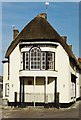
4
The Square, Puddletown
Looking east from Mill St towards the Church. This interesting house has an unusual bay window supported on columns.
Image: © Nigel Mykura
Taken: 13 Jul 2008
0.06 miles
5
![Puddletown houses [16]](https://s3.geograph.org.uk/geophotos/06/77/34/6773439_3229bca1_120x120.jpg)
Puddletown houses [16]
Number 4 The Square is 18th century, with plastered walls and a thatched roof, incorporating an earlier structure. On the right is an extension of circa 1980 in brick. Listed, grade II, with details at: https://historicengland.org.uk/listing/the-list/list-entry/1324014
The village of Puddletown, earlier known as Piddletown is located alongside the River Piddle some 4½ miles north east of Dorchester and is now essentially a commuter village. There is evidence of occupation from prehistoric times in the form of some 30 round barrows. The use of watermeadows in Dorset was first developed in Puddletown in the 17th century. The village was the inspiration for the fictional settlement of Weatherbury in the novel Far from the Madding Crowd by Thomas Hardy.
Image: © Michael Dibb
Taken: 11 Dec 2020
0.06 miles
7
Puddletown: The Square from St. Mary's Church
Image: © Michael Garlick
Taken: 23 Apr 2016
0.06 miles
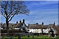
8
![Puddletown houses [15]](https://s0.geograph.org.uk/geophotos/06/77/34/6773436_d96b6bba_120x120.jpg)
Puddletown houses [15]
This range of buildings is three properties, Troy House, Middle House and Well House. Possibly originally one large property built in the mid to late 18th century with plastered walls and thatched roof. There is an 18th century shop front and a very fine Venetian bay window on the end of the range supported on Tuscan columns protected by railings. Some original internal features remain. Listed, grade II, with details at: https://historicengland.org.uk/listing/the-list/list-entry/1154504
The village of Puddletown, earlier known as Piddletown is located alongside the River Piddle some 4½ miles north east of Dorchester and is now essentially a commuter village. There is evidence of occupation from prehistoric times in the form of some 30 round barrows. The use of watermeadows in Dorset was first developed in Puddletown in the 17th century. The village was the inspiration for the fictional settlement of Weatherbury in the novel Far from the Madding Crowd by Thomas Hardy.
Image: © Michael Dibb
Taken: 11 Dec 2020
0.06 miles
10
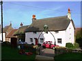
Pink-washed thatched cottage, Puddletown
Image: © nick macneill
Taken: 19 Nov 2011
0.07 miles