IMAGES TAKEN NEAR TO
The Gardens, DORCHESTER, DT2 8QG
Introduction
This page details the photographs taken nearby to The Gardens, DT2 8QG by members of the Geograph project.
The Geograph project started in 2005 with the aim of publishing, organising and preserving representative images for every square kilometre of Great Britain, Ireland and the Isle of Man.

There are currently over 7.5m images from over14,400 individuals and you can help contribute to the project by visiting https://www.geograph.org.uk
Image Map
Images are licensed for reuse under creativecommons.org/licenses/by-sa/2.0
Notes
- Clicking on the map will re-center to the selected point.
- The higher the marker number, the further away the image location is from the centre of the postcode.
Image Listing (11 Images Found)
Images are licensed for reuse under creativecommons.org/licenses/by-sa/2.0
Image
Details
Distance
1
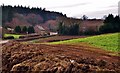
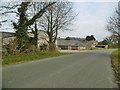
Troy Town: Buildings near Puddletown
Image: © Mr Eugene Birchall
Taken: 16 Feb 2012
0.10 miles
2
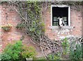
The Old Nag's Head, Troy Town Farm
The farm is on the old A35 at Troy town just outside Puddletown on the road to Dorchester. This occupant was actively engaged in keeping an eye on intruders and probably looking for a feed bucket or two.
Image: © Nigel Mykura
Taken: 13 Jul 2008
0.12 miles
3
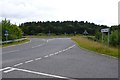
Troy Town Junction.
Junction of the old A35 and the new Puddletown bypass at Troy town just outside Puddletown
Image: © Nigel Mykura
Taken: 13 Jul 2008
0.12 miles
4
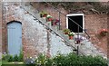
Stable Block Troy Town farm
The stairs rise up from the stable yard to the hayloft above at this old farm at Troytown just east of Dorchester on the old road to Puddletown
Image: © Nigel Mykura
Taken: 14 Jul 2008
0.12 miles
5
Puddletown, Troytown Farm
On the former A35 road.
Image: © Mike Faherty
Taken: 14 Jan 2018
0.14 miles
6
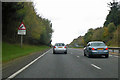
Queues likely on westbound A35
This is because the end of the dual carriageway section is over the hill.
Image: © Robin Webster
Taken: 3 Nov 2018
0.14 miles
7
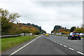
A35 at slip road from Puddletown
Joining the westbound carriageway.
Image: © Robin Webster
Taken: 3 Nov 2018
0.21 miles
9
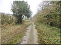
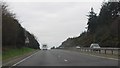
Puddletown, former A35
Running roughly parallel to the current A35; described by a DCC sign as "Public Route to Public Path". The road retains its catseye frames.
Image: © Mike Faherty
Taken: 14 Jan 2018
0.23 miles
10
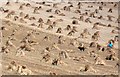
One Man and his Dog
This field of sheaves of straw is just next to the Puddletown bypass, the A35 at Troy Town just east of Dorchester. The sheaves are probably going to be used for thatching, hence the harvesting of the stems rather than the ears of wheat. The sheaves had been stacked vertically in the sun to dry for several days and were now being laid out ready for collection.
Image: © Nigel Mykura
Taken: 28 Jul 2010
0.23 miles