IMAGES TAKEN NEAR TO
School Lane, DORCHESTER, DT2 8JX
Introduction
This page details the photographs taken nearby to School Lane, DT2 8JX by members of the Geograph project.
The Geograph project started in 2005 with the aim of publishing, organising and preserving representative images for every square kilometre of Great Britain, Ireland and the Isle of Man.

There are currently over 7.5m images from over14,400 individuals and you can help contribute to the project by visiting https://www.geograph.org.uk
Image Map
Images are licensed for reuse under creativecommons.org/licenses/by-sa/2.0
Notes
- Clicking on the map will re-center to the selected point.
- The higher the marker number, the further away the image location is from the centre of the postcode.
Image Listing (22 Images Found)
Images are licensed for reuse under creativecommons.org/licenses/by-sa/2.0
Image
Details
Distance
1
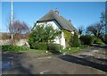
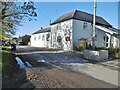
Winfrith Newburgh, Old Dairy Cottage
C18 cottage and former barn; Grade II listed by Historic England: https://historicengland.org.uk/listing/the-list/list-entry/1323366
Image: © Mike Faherty
Taken: 4 Nov 2020
0.00 miles
2
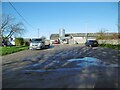
Winfrith Newburgh, farm entrance
Draytons Dairy, on School Lane.
Image: © Mike Faherty
Taken: 4 Nov 2020
0.01 miles
3
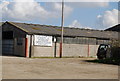
Drayton Dairy, Winfrith Newburgh
One of many dairy farms in this part of Dorset, the grass grows well here!
Image: © N Chadwick
Taken: 9 Apr 2008
0.02 miles
4
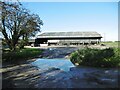
Winfrith Newburgh, cow shed
Holsteins at Draytons Dairy.
Image: © Mike Faherty
Taken: 4 Nov 2020
0.03 miles
5
Winfrith Newburgh, school
Lulworth & Winfrith CE VC School, on School Lane: https://www.lulworthwinfrith.dorset.sch.uk/
Image: © Mike Faherty
Taken: 4 Nov 2020
0.07 miles
6
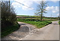
Road junction, Winfrith Newburgh.
Rural road junction
Image: © N Chadwick
Taken: 9 Apr 2008
0.13 miles
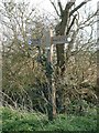
7
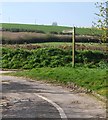
Signpost to Coombe Keynes
Although this looks like a road sign, this road quickly becomes a bridleway & impassable to vehicles.
Image: © N Chadwick
Taken: 9 Apr 2008
0.14 miles
8
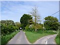
Road Junction west of Winfrith Newburgh
The road going off on the right which is more of a track and is marked on the map as being "other route with public access" has a signpost saying Claypits Farm.
Image: © Nigel Mykura
Taken: 16 May 2009
0.14 miles
9
How far exactly?
I checked this one, and we are actually 2/5ths of a mile from Winfrith Newburgh. Yet some slapdash signwriter has put the more approximate figure of 3/8ths of a mile.
Image: © David Hodd
Taken: 1 Apr 2007
0.15 miles
10
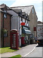
Winfrith Newburgh: post office, postbox № DT2 135 and phone
The frontage of the post office (called plain 'Winfrith') will soon catch the direct sunlight; it is already penetrating the opaque oval sign giving almost the impression of being illuminated from inside.
The modern postbox is emptied finally at 4pm on weekdays and at 9:30am on Saturdays.
Image: © Chris Downer
Taken: 25 Jul 2009
0.18 miles