IMAGES TAKEN NEAR TO
Warmwell, DORCHESTER, DT2 8JD
Introduction
This page details the photographs taken nearby to DT2 8JD by members of the Geograph project.
The Geograph project started in 2005 with the aim of publishing, organising and preserving representative images for every square kilometre of Great Britain, Ireland and the Isle of Man.

There are currently over 7.5m images from over14,400 individuals and you can help contribute to the project by visiting https://www.geograph.org.uk
Image Map (Loading...)


Getting Data...Please wait
Leaflet Map data © OpenStreetMap
Images are licensed for reuse under creativecommons.org/licenses/by-sa/2.0
Notes
- Clicking on the map will re-center to the selected point.
- The higher the marker number, the further away the image location is from the centre of the postcode.
Image Listing (13 Images Found)
Images are licensed for reuse under creativecommons.org/licenses/by-sa/2.0
Image
Details
Distance
1
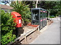
Crossways: postbox № DT2 403, Warmwell Holiday Park
This modern postbox and its neighbouring phone boxes serve a large holiday park, now just north of Warmwell parish which gives it its name – although Crossways has only been a separate parish in the last 20 years or so. The box is emptied at 9 o'clock each weekday and Saturday morning.
Image: © Chris Downer
Taken: 20 Jun 2009
0.12 miles
3
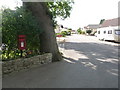
Crossways: postbox № DT2 208, Oaklands Park
This postbox stands at the entrance to a static mobile homes park. It is emptied at half past ten each weekday and Saturday morning.
Image: © Chris Downer
Taken: 20 Jun 2009
0.12 miles
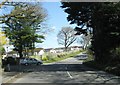
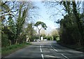
5
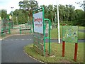
Warmwell Holiday Park
This holiday park is just south of Crossways, Dorset.
Image: © Stuart Buchan
Taken: 8 Jul 2005
0.17 miles
6
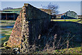
WWII Dorset: discovering RAF Warmwell (35)
-
Airfield - Bellman Hangar # 1 (site of)
At one time on this site on the south side of the airfield there were two Bellman hangars, now just one of them remains, seen in the background alongside a Romney hut. Still standing is the brick-built blast wall that once protected the demolished hangar's north east side. As for the Romney hut, it is doubtful if it was ever part of RAF Warmwell, as it is not on the original 1946 site plan, and may have been placed here by the farmer post war.
Image
Image: © Mike Searle
Taken: 19 Jan 2020
0.18 miles
7
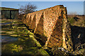
WWII Dorset: discovering RAF Warmwell (36)
-
Airfield - Bellman Hangar # 1 (site of)
The demolished Bellman hangar's surviving blast wall showing the wall's buttressing on this side. In front of the wall is the hangar's extant concrete floor.
Image
Image: © Mike Searle
Taken: 19 Jan 2020
0.18 miles
8
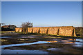
WWII Dorset: discovering RAF Warmwell (37)
-
Airfield - Bellman Hangar # 1 (site of)
Showing the full length of the surviving blast wall, and the demolished hangar's concrete floor.
Image
Image: © Mike Searle
Taken: 19 Jan 2020
0.19 miles
9
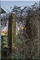
WWII Dorset: discovering RAF Warmwell (39)
-
Airfield - Bellman Hangar # 2
A surviving fragment of the blast wall that at one time would have protected the whole of one side of this hangar.
Image
Image: © Mike Searle
Taken: 19 Jan 2020
0.23 miles
10
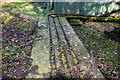
WWII Dorset: discovering RAF Warmwell (41)
-
Airfield - Bellman Hangar # 2
The runners for the hangar doors.
This is the last in the series on RAF Warmwell that has in recent years been commemorated by a memorial in the village of Crossways, a new development that was built after the war on the site of the old airfield. Image
START: Image
Image: © Mike Searle
Taken: 19 Jan 2020
0.23 miles