IMAGES TAKEN NEAR TO
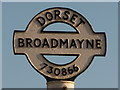
Charlmont Cross, DORCHESTER, DT2 8EY
Introduction
This page details the photographs taken nearby to Charlmont Cross, DT2 8EY by members of the Geograph project.
The Geograph project started in 2005 with the aim of publishing, organising and preserving representative images for every square kilometre of Great Britain, Ireland and the Isle of Man.

There are currently over 7.5m images from over14,400 individuals and you can help contribute to the project by visiting https://www.geograph.org.uk
Image Map (Loading...)


Getting Data...Please wait
Leaflet Map data © OpenStreetMap
Images are licensed for reuse under creativecommons.org/licenses/by-sa/2.0
Notes
- Clicking on the map will re-center to the selected point.
- The higher the marker number, the further away the image location is from the centre of the postcode.
Image Listing (111 Images Found)
Images are licensed for reuse under creativecommons.org/licenses/by-sa/2.0
Image
Details
Distance
2
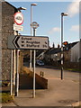
Broadmayne: signposts at the crossroads
The signs are modern, but the finial from the original fingerpost has been retained – we can see it close up here: Image
Image: © Chris Downer
Taken: 13 Feb 2010
0.02 miles
3
Broadmayne: old finger-post detail
A close-up of the finial from the original finger-post, which has been retained and mounted on top of the modern signage here: Image
Image: © Chris Downer
Taken: 13 Feb 2010
0.02 miles
4
![Broadmayne features [2]](https://s3.geograph.org.uk/geophotos/07/26/14/7261435_dc6c6402_120x120.jpg)
Broadmayne features [2]
An information board about the history of the village.
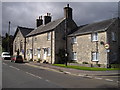
Broadmayne is a village in Dorset, some 3 miles southeast of Dorchester. The village is astride the A352 road from Dorchester to Wareham. There is evidence of settlement from the Stone Age onwards. In addition to agricultural activities, there was a brickworks to the north of the village. At the approach of D-Day in 1944, the area around the village was covered with Nissen huts and tents as assembly area D5 for the invasion.
Image: © Michael Dibb
Taken: 2 Jun 2022
0.02 miles
5
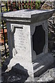
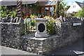
Broadmayne millennium time capsule
The inscription reads, "A time capsule containing 20th C artefacts was placed here by children of Broadmayne June 2000.
Image: © John Stephen
Taken: 7 Jul 2014
0.03 miles
6
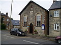
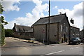
Broadmayne Methodist Church, Main Street
Wesleyan chapel added to the village of Broadmayne in 1865 by W. Hammett, a relation of one of the Tolpuddle Martyrs, James Hammett.
Image: © Peter Holmes
Taken: 17 Nov 2012
0.03 miles
7
![Broadmayne buildings [1]](https://s1.geograph.org.uk/geophotos/07/26/14/7261445_0c1d63cb_120x120.jpg)
Broadmayne buildings [1]
Broadmayne Methodist church, Main Street, was built as a Wesleyan chapel in 1865. Constructed of coursed rubble stone with rick dressings and quoins under a slate roof.
Broadmayne is a village in Dorset, some 3 miles southeast of Dorchester. The village is astride the A352 road from Dorchester to Wareham. There is evidence of settlement from the Stone Age onwards. In addition to agricultural activities, there was a brickworks to the north of the village. At the approach of D-Day in 1944, the area around the village was covered with Nissen huts and tents as assembly area D5 for the invasion.
Image: © Michael Dibb
Taken: 2 Jun 2022
0.03 miles
8
Broadmayne millennium time capsule
A time capsule created by the Broadmayne school to mark the millennium in 2000. On the corner of Main Street and Chalky Road.
Image: © John Stephen
Taken: 7 Jul 2014
0.03 miles
9
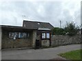
Village shelter and noticeboards, Broadmayne
The shelter has no seat, and covers the noticeboard. It is too close to a pedestrian crossing to be a bus shelter
Image: © David Smith
Taken: 1 Oct 2020
0.03 miles