IMAGES TAKEN NEAR TO
Empool Close, DORCHESTER, DT2 8BX
Introduction
This page details the photographs taken nearby to Empool Close, DT2 8BX by members of the Geograph project.
The Geograph project started in 2005 with the aim of publishing, organising and preserving representative images for every square kilometre of Great Britain, Ireland and the Isle of Man.

There are currently over 7.5m images from over14,400 individuals and you can help contribute to the project by visiting https://www.geograph.org.uk
Image Map
Images are licensed for reuse under creativecommons.org/licenses/by-sa/2.0
Notes
- Clicking on the map will re-center to the selected point.
- The higher the marker number, the further away the image location is from the centre of the postcode.
Image Listing (14 Images Found)
Images are licensed for reuse under creativecommons.org/licenses/by-sa/2.0
Image
Details
Distance
1
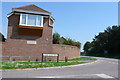
New housing at Crossways
A modern development on the very edge of the village named after the imaginary "Egdon Heath" of Hardy's Wessex novels.
Image: © Nigel Mykura
Taken: 11 May 2008
0.03 miles
2
WWII Dorset: discovering RAF Warmwell (12)
-
The Airfield - Aircraft "tie downs"
Here in the south east corner of the airfield are a number of concrete blocks that have been excavated by the developer of the land. These are aircraft "tie-down" anchors that were used to secure parked aircraft to minimise the possibility of untoward movement due to high winds or propeller wash. They would have originally been sunk into the ground at the dispersals below the aircraft, the tops of the anchoring points flush with the surface.
Today, the site of the former airfield is either under development, or subject to extensive quarrying, the latter activity has unfortunately all but obliterated much of what used to remain.
Image
Image: © Mike Searle
Taken: 10 Jan 2020
0.05 miles
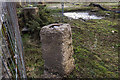
4
Detail from the RAF Warmwell Memorial Crossways
Image: © Mike Searle
Taken: 21 May 2008
0.07 miles
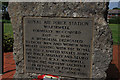
5
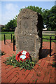
RAF Warmwell Memorial at Crossways
The aptly named village of Crossways was created after the war on the site of the former RAF station Warmwell, made famous as a Battle of Britain fighter station. During the Battle, it hosted two squadrons of Spitfires, providing protection for the nearby naval base at Portland, as well as other coastal installations. It continued as a fighter station for the duration of the war, and was Dorset's only RAF fighter base, with many different aircraft types flying from here. In March 1944 the station hosted the 474th Fighter Group of the USAAF flying P38 Lightnings during D-Day and the aftermath. The memorial was commissioned to commemorate those who served at Warmwell who died in the cause of freedom. Image
Image: © Mike Searle
Taken: 21 May 2008
0.08 miles
6
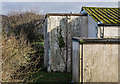
WWII Dorset: discovering RAF Warmwell (2)
-
Cinema/Gymnasium
This extension on the end was the cinema projection booth.
Image
Image: © Mike Searle
Taken: 10 Jan 2020
0.11 miles
7
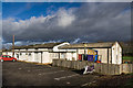
WWII Dorset: discovering RAF Warmwell (1)
-
Cinema/Gymnasium
Today this is Crossway's village hall that during the war served a dual purpose as RAF Warmwell's Station Cinema and Gymnasium. The lower attached building fronting the car park comprised both officer's and men's changing rooms, and two store rooms.
Image
OVERVIEW
RAF Warmwell was opened in May 1937 as 6 Armament Training Camp, a gunnery school. It was known then as RAF Woodsford, but was renamed the following year as RAF Warmwell due to the possibility of it being confused with Woodford, near Manchester. By July 1940 it came under the control of Fighter Command's 10 Group, to become a satellite of RAF Middle Wallop. Dorset's only RAF fighter station during the Battle of Britain, its airfield would play a major role in the defence of the naval base at Portland, as well as providing protection for other important south coast areas. The three runways were of grass, and remained so for the duration of the war. The airfield came under attack by the Luftwaffe on several occasions, one in particular in the spring of 1941 left several personnel dead.
Inevitably as the war progressed, the role emphasis changed when offensive operations into German occupied Europe were undertaken with Spitfires, Hurricanes, Tempests, and the Westland Whirlwind, the RAF's first twin engined heavy fighter. Although RAF Warmwell was mainly an RAF station, the USAAF also made use of the airfield for brief periods during 1942, and again in March 1944 when the station came under USAAF control completely to become USAAF Station AAF-454. When the 474th Fighter Group with their Lockheed P-38 Lightnings departed for continental Europe in August 1944, the station reverted back to the RAF. The last RAF squadrons left in October 1945, and the following month the station entered a period under Care and Maintenance before closing down in 1946.
Image: © Mike Searle
Taken: 10 Jan 2020
0.12 miles
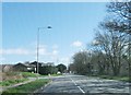
9
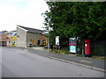
Crossways: post office, postbox № DT2 50 and phone
The general store and post office in Mount Skippet Way. The large, Elizabeth II-reign postbox is emptied finally at 4:30pm on weekdays and at 11am on Saturdays.
Image: © Chris Downer
Taken: 20 Jun 2009
0.13 miles
10
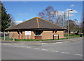
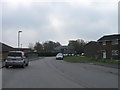
Crossways Library
The village of Crossways was built on the site of the former RAF station, Royal Air Force Warmwell (formerly RAF Woodsford). Famous as a Battle of Britain fighter station, many of its combatants lie buried in the churchyard in the nearby village of Warmwell Image
Image: © Mike Searle
Taken: 21 Mar 2007
0.13 miles