IMAGES TAKEN NEAR TO
Piddlehinton, DORCHESTER, DT2 7TH
Introduction
This page details the photographs taken nearby to DT2 7TH by members of the Geograph project.
The Geograph project started in 2005 with the aim of publishing, organising and preserving representative images for every square kilometre of Great Britain, Ireland and the Isle of Man.

There are currently over 7.5m images from over14,400 individuals and you can help contribute to the project by visiting https://www.geograph.org.uk
Image Map
Images are licensed for reuse under creativecommons.org/licenses/by-sa/2.0
Notes
- Clicking on the map will re-center to the selected point.
- The higher the marker number, the further away the image location is from the centre of the postcode.
Image Listing (4 Images Found)
Images are licensed for reuse under creativecommons.org/licenses/by-sa/2.0
Image
Details
Distance
1
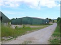
Carters Barn Farm
This is the bridle path that runs alongside the farm. The large barn is just inside the southern edge of the grid square.
Image: © Nigel Mykura
Taken: 11 Jul 2010
0.01 miles
2
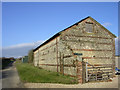
Carter's Barn on Carter's Barn Farm
This old barn is presumably what gave Carter's Barn Farm (a much more recent construction) its name.
Image: © Jim Champion
Taken: 25 Dec 2005
0.08 miles
3
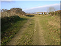
Bridleway north of Carter's Barn Farm
This grid square contains little except agricultural farmland. This view is looking north towards a T-junction of bridleways north of Carter's Barn Farm.
Image: © Jim Champion
Taken: 25 Dec 2005
0.09 miles
4
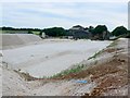
Bourne Park
This is a large agricultural establishment that includes a piggery that you certainly know is there when the wind is blowing in the right direction. View from the road running alongside. A large excavation had been made in the chalk for the base of a new building.
Image: © Nigel Mykura
Taken: 11 Jul 2010
0.21 miles