IMAGES TAKEN NEAR TO
Wills Lane, DORCHESTER, DT2 7JY
Introduction
This page details the photographs taken nearby to Wills Lane, DT2 7JY by members of the Geograph project.
The Geograph project started in 2005 with the aim of publishing, organising and preserving representative images for every square kilometre of Great Britain, Ireland and the Isle of Man.

There are currently over 7.5m images from over14,400 individuals and you can help contribute to the project by visiting https://www.geograph.org.uk
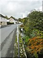
Image Map
Images are licensed for reuse under creativecommons.org/licenses/by-sa/2.0
Notes
- Clicking on the map will re-center to the selected point.
- The higher the marker number, the further away the image location is from the centre of the postcode.
Image Listing (354 Images Found)
Images are licensed for reuse under creativecommons.org/licenses/by-sa/2.0
Image
Details
Distance
3

Cerne Abbas: postbox № DT2 52, The Folly
A Victorian box set into a wall on the north side of the road called The Folly. It is emptied at 10:30 each weekday and Saturday morning.
Image: © Chris Downer
Taken: 7 Jun 2009
0.07 miles
4
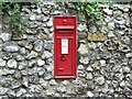
Postbox, Cerne Abbas
Victorian postbox in the flint wall of The Folly.
Image: © Maigheach-gheal
Taken: 15 Jun 2009
0.07 miles
6
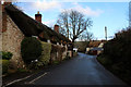
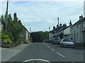
The Folly, Cerne Abbas
The Folly is the name of this road that is heading east into the village of Cerne Abbas
Image: © Chris Heaton
Taken: 4 Feb 2019
0.08 miles
7
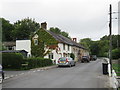
Duck Street, Cerne Abbas
Duck Street in the village of Cerne Abbas in Dorset.
Image: © Malc McDonald
Taken: 21 Aug 2020
0.08 miles
8
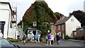
Cerne Abbas, village school
Cerne Abbas CoE First School; handsome stone and flint building on Duck Street. http://www.cerneabbas.dorset.sch.uk/
Image: © Mike Faherty
Taken: 13 Jun 2010
0.08 miles
9
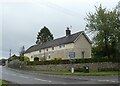
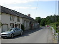
Cerne Abbas, Duck Street
Street from the village centre northwards to A352; to the right, modern properties separated from the highway by a stream which feeds into River Cerne to the South; on the left, further away, the village school.
Image: © Mike Faherty
Taken: 13 Jun 2010
0.08 miles
10
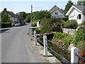
Cerne Abbas, River Cerne
Looking upstream on Duck Street. The river at this point is a mere trickle, because much of its strength was diverted to feed a mill. See also Image
Image: © Mike Faherty
Taken: 28 Oct 2015
0.08 miles