IMAGES TAKEN NEAR TO
Evershot Walk, DORCHESTER, DT1 3GA
Introduction
This page details the photographs taken nearby to Evershot Walk, DT1 3GA by members of the Geograph project.
The Geograph project started in 2005 with the aim of publishing, organising and preserving representative images for every square kilometre of Great Britain, Ireland and the Isle of Man.

There are currently over 7.5m images from over14,400 individuals and you can help contribute to the project by visiting https://www.geograph.org.uk
Image Map (Loading...)


Getting Data...Please wait
Leaflet Map data © OpenStreetMap
Images are licensed for reuse under creativecommons.org/licenses/by-sa/2.0
Notes
- Clicking on the map will re-center to the selected point.
- The higher the marker number, the further away the image location is from the centre of the postcode.
Image Listing (107 Images Found)
Images are licensed for reuse under creativecommons.org/licenses/by-sa/2.0
Image
Details
Distance
1
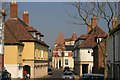
Middlemarsh Street
Looking up Middlemarsh Street in Poundbury Village Dorchester. It shows some of the interesting architecture which is part of Prince Charles' vision for the village which was built on Duchy of Cornwall land.
The Duchy of Cornwall website http://www.duchyofcornwall.org/designanddevelopment_poundbury.htm
Image: © Marilyn Peddle
Taken: 27 Mar 2007
0.03 miles
2
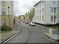
Middlemarsh Street Dorchester
New housing off Bridport Road
Image: © John Firth
Taken: 14 May 2010
0.03 miles
3
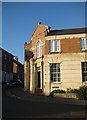
A corner of Pummery Square Poundbury
Echoes of 18th Century architecture?
Pummery is the name Thomas Hardy gave Poundbury Camp hill fort.
Image: © Sarah Smith
Taken: 24 Oct 2008
0.03 miles
4
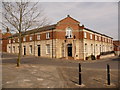
Poundbury: Cambridge Walk corner
Looking across the northeast corner of Pummery Square, with Middlemarsh Street to the left (giving access to/from this part of the estate) and Cambridge Walk to the right.
Image: © Chris Downer
Taken: 10 Apr 2010
0.03 miles
5
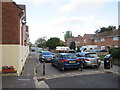
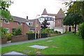
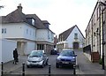
Boundary of Poundbury and Dorchester
The row of posts marks the boundary between Poundbury and Dorchester.
Beyond the posts is Cambridge Road, a residential road in Dorchester.
Image: © Malc McDonald
Taken: 18 Aug 2020
0.04 miles
6
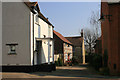
Cottages
New cottages, Poundbury just off Middlemarsh street. The design and layout retains the village feel of Poundbury.
Image: © Marilyn Peddle
Taken: 27 Mar 2007
0.04 miles
7
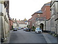
Longmoor Street, Poundbury
Longmoor Street is a residential road in the recently-developed "urban village" of Poundbury in Dorset.
Image: © Malc McDonald
Taken: 18 Aug 2020
0.04 miles
8
Old and new at Poundbury
Poundbury Village is characterised by its modern architecture with a traditional look. The new village meets the slightly older part of Dorchester here on the Bridport Rd. On the left 1970's social housing.On the right the modern old towers of Poundbury
Image: © Nigel Mykura
Taken: 12 Jul 2008
0.04 miles
9
Cambridge Rd Poundbury, Dorchester
This small bit of road is actually part of Cambridge Rd, a long road in the Victoria Park area of Dorchester but the metal bollards give a physical barrier which prevents vehicular access to Poundbury. All the minor roads between the two areas are closed off like this giving the feeling that someone is being kept out, but it also prevents a new through route being formed. Brownsword Hall (the Poundbury Village hall) can be seen at the top of the street in Pummery Square.
Image: © Nigel Mykura
Taken: 1 Mar 2011
0.05 miles
10
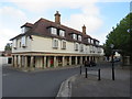
Poundbury Village Stores
Poundbury Village Stores is one of several local convenience stores in Poundbury. The building has been made to look traditional but, like everything in Poundbury, it is quite recently-built. Poundbury is a new "urban village" which has been developed since the 1990s.
Image: © Malc McDonald
Taken: 18 Aug 2020
0.05 miles