IMAGES TAKEN NEAR TO
Knapwater Walk, DORCHESTER, DT1 2TS
Introduction
This page details the photographs taken nearby to Knapwater Walk, DT1 2TS by members of the Geograph project.
The Geograph project started in 2005 with the aim of publishing, organising and preserving representative images for every square kilometre of Great Britain, Ireland and the Isle of Man.

There are currently over 7.5m images from over14,400 individuals and you can help contribute to the project by visiting https://www.geograph.org.uk
Image Map (Loading...)


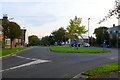
Getting Data...Please wait
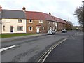
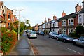
Leaflet Map data © OpenStreetMap
Images are licensed for reuse under creativecommons.org/licenses/by-sa/2.0
Notes
- Clicking on the map will re-center to the selected point.
- The higher the marker number, the further away the image location is from the centre of the postcode.
Image Listing (63 Images Found)
Images are licensed for reuse under creativecommons.org/licenses/by-sa/2.0
Image
Details
Distance
1
Ivel Close
This is one of the short residential streets built on the site of the old Thomas Hardye School. The trees at the end mark the pedestrian section of Barnes Way. The housing development resulted in a large central part of Barnes way disappearing leaving two unconnected sections at either end and also this small pedestrian pathway.
Image: © Nigel Mykura
Taken: 4 Jan 2011
0.02 miles
2

Manor Rd Dorchester
View NE close to the junction with South Court Avenue
Image: © Nigel Mykura
Taken: 10 Oct 2008
0.05 miles
3

Junction Of South Court Avenue and Manor Rd Dorchester
Looking north from Manor Rd, the houses are on the N side of South Court Avenue
Image: © Nigel Mykura
Taken: 10 Oct 2008
0.06 miles
4
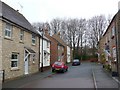
Moynton Rd
A modern housing development on the site of the old Thomas Hardye School.
Image: © Nigel Mykura
Taken: 4 Jan 2011
0.06 miles
5
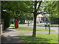
Post Box and Roundabout at end of South Court Avenue, Dorchester
Image: © Gary Rogers
Taken: 11 May 2017
0.06 miles
6
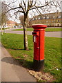
Dorchester: postbox № DT1 81, South Court Avenue
This Elizabeth II-reign postbox stands by the roundabout at the eastern end of South Court Avenue. It is emptied finally at 5:30pm on weekdays and at 11:30am on Saturdays.
Image: © Chris Downer
Taken: 10 Apr 2010
0.07 miles
7
Eastern end of South Court Avenue Dorchester
This roundabout is where Culliford Rd, Barnes Way and South Court Avenue meet up with Lucetta Drive
Image: © Nigel Mykura
Taken: 9 Oct 2008
0.07 miles
8

Manor Rd Dorchester
The leafy Manor Park suburb of Dorchester which has wide quiet streets with lots of trees
Image: © Nigel Mykura
Taken: 10 Oct 2008
0.08 miles
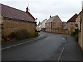
9
Lucetta Lane Dorchester
One of the many roads that are named after Thomas Hardy characters. Lucette Le Sueur is a french speaking woman from Jersey in the novel The Mayor of Casterbridge. She is the lover of Henchard who is the mayor in the title of the book. This photo was taken from close to the junction with South Court Avenue and Culliford Rd.
Image: © Nigel Mykura
Taken: 19 Jan 2010
0.08 miles
10
Culliford Road South, Dorchester
Culliford Rd runs south from Prince of Wales Road across the railway to the Manor park area of Dorchester. This is the view from the southern end near South Court Avenue looking north.
Image: © Nigel Mykura
Taken: 9 Oct 2008
0.09 miles