IMAGES TAKEN NEAR TO
Holbaek Close, DORCHESTER, DT1 2SH
Introduction
This page details the photographs taken nearby to Holbaek Close, DT1 2SH by members of the Geograph project.
The Geograph project started in 2005 with the aim of publishing, organising and preserving representative images for every square kilometre of Great Britain, Ireland and the Isle of Man.

There are currently over 7.5m images from over14,400 individuals and you can help contribute to the project by visiting https://www.geograph.org.uk
Image Map (Loading...)


Getting Data...Please wait
Leaflet Map data © OpenStreetMap
Images are licensed for reuse under creativecommons.org/licenses/by-sa/2.0
Notes
- Clicking on the map will re-center to the selected point.
- The higher the marker number, the further away the image location is from the centre of the postcode.
Image Listing (6 Images Found)
Images are licensed for reuse under creativecommons.org/licenses/by-sa/2.0
Image
Details
Distance
1
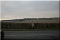
Reaching the A35 ring road, Dorchester
The footpath across the fields to the North Plantation can be seen in the distance.
Image: © Becky Williamson
Taken: 6 Feb 2015
0.11 miles
2
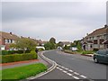
Shaston Crescent
Thomas Hardy's name for Shaftesbury gave this road its name.
Image: © Nigel Mykura
Taken: 15 Sep 2008
0.21 miles
3
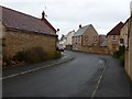
Moynton Rd
A modern housing development on the site of the old Thomas Hardye School.
Image: © Nigel Mykura
Taken: 4 Jan 2011
0.22 miles
4
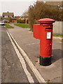
Dorchester: postbox № DT1 195, Egdon Road
A George VI-reign postbox, with a last collection at 5:30pm on weekdays and at 11:30am on Saturdays.
The telephone box in the background is in Mellstock Avenue.
Image: © Chris Downer
Taken: 10 Apr 2010
0.22 miles
5

Mellstock Avenue , Dorchester
One of the many "Hardy" roads in the town. Small shopping centre, once containing ordinary grocery type shops now mostly small service businesses.
Image: © Nigel Mykura
Taken: 15 Sep 2008
0.22 miles
6
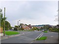
Barnes Way Dorchester
The junction with Rothesay Rd with St Osmunds School in the background.
Image: © Nigel Mykura
Taken: 15 Sep 2008
0.24 miles