IMAGES TAKEN NEAR TO
Hawthorn Road, DORCHESTER, DT1 2PD
Introduction
This page details the photographs taken nearby to Hawthorn Road, DT1 2PD by members of the Geograph project.
The Geograph project started in 2005 with the aim of publishing, organising and preserving representative images for every square kilometre of Great Britain, Ireland and the Isle of Man.

There are currently over 7.5m images from over14,400 individuals and you can help contribute to the project by visiting https://www.geograph.org.uk
Image Map (Loading...)


Getting Data...Please wait
Leaflet Map data © OpenStreetMap
Images are licensed for reuse under creativecommons.org/licenses/by-sa/2.0
Notes
- Clicking on the map will re-center to the selected point.
- The higher the marker number, the further away the image location is from the centre of the postcode.
Image Listing (139 Images Found)
Images are licensed for reuse under creativecommons.org/licenses/by-sa/2.0
Image
Details
Distance
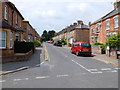
2
Mountain Ash Road
A street of victorian housing mainly terraced, on the N side of the Bridport Rd
Image: © Nigel Mykura
Taken: 26 Sep 2008
0.02 miles
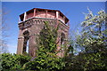
3
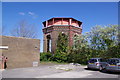
Dorchester - Watertower
This watertower was built in 1880 and is Grade II listed.
Image: © Chris Talbot
Taken: 1 Apr 2012
0.03 miles
4
Dorchester - Watertower
This watertower was built in 1880 and is Grade II listed.
Image: © Chris Talbot
Taken: 1 Apr 2012
0.03 miles
5
Dorchester - Watertower
This watertower was built in 1880 and is Grade II listed.
Image: © Chris Talbot
Taken: 1 Apr 2012
0.03 miles
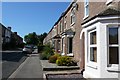
6
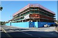
New Apartments and Shops Bridport Rd
These are being built on the site of a former car dealership.
Image: © Nigel Mykura
Taken: 26 Sep 2008
0.04 miles
7
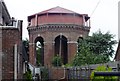
Victorian Water Tower, Dorchester
Picture taken from Hawthorne Road. The lengths that the Victorians went to to build something of style, never ceases to amaze me. The detailed brickwork around the base of the tank is incredible.
Image: © Ian Andrews
Taken: 21 Jun 2013
0.04 miles
8
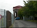
Dorchester, water tower
Victorian-looking tower, between the junction of Bridport & Wessex Roads; operated by Wessex Water, officially part of Bridport Road Water Supply Depot.
Image: © Mike Faherty
Taken: 15 Sep 2009
0.04 miles
9
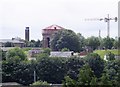
Water Tower from Poundbury Hill Fort
This is the view from the ramparts of Poundbury Hill Fort looking roughly south south east. The large chimney with the blue cap to the left is the Dorset County Hospital Chimney. The crane is working on the old fire station site and in the centre is the Victorian water tower. The two field maples in front of the tower are probably the only trees in Dorset that I'd like to see removed; just so I could get a better view of the water tower. The collection of small buildings in front of the tower are those of the water works and you can just see the edge of the small covered reservoir on the right.
Image: © Ian Andrews
Taken: 21 Jun 2013
0.04 miles
10
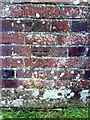
Benchmark on Wessex Water's water tower
Ordnance Survey cut mark benchmark described on the Bench Mark Database at http://www.bench-marks.org.uk/bm25174. The tower is shown at Image
Image: © Roger Templeman
Taken: 30 Dec 2010
0.04 miles