IMAGES TAKEN NEAR TO
Mountain Ash Road, DORCHESTER, DT1 2PB
Introduction
This page details the photographs taken nearby to Mountain Ash Road, DT1 2PB by members of the Geograph project.
The Geograph project started in 2005 with the aim of publishing, organising and preserving representative images for every square kilometre of Great Britain, Ireland and the Isle of Man.

There are currently over 7.5m images from over14,400 individuals and you can help contribute to the project by visiting https://www.geograph.org.uk
Image Map (Loading...)


Getting Data...Please wait
Leaflet Map data © OpenStreetMap
Images are licensed for reuse under creativecommons.org/licenses/by-sa/2.0
Notes
- Clicking on the map will re-center to the selected point.
- The higher the marker number, the further away the image location is from the centre of the postcode.
Image Listing (150 Images Found)
Images are licensed for reuse under creativecommons.org/licenses/by-sa/2.0
Image
Details
Distance
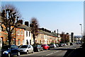
1
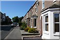
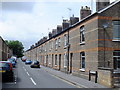
Mountain Ash Road
A street of victorian housing mainly terraced, on the N side of the Bridport Rd
Image: © Nigel Mykura
Taken: 26 Sep 2008
0.03 miles
2
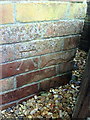
Benchmark on #33 Mountain Ash Road
Ordnance Survey cut mark benchmark described on the Bench Mark Database at http://www.bench-marks.org.uk/bm29047
Image: © Roger Templeman
Taken: 30 Dec 2010
0.04 miles
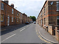
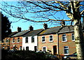
5
Prospect Road, Dorchester
A fine row of Victorian cottages. Detail in the brickwork just out of view on the end cottage nearest the camera proclaims that they were built in 1885. Hopefully one day someone will invent a minute, almost invisible, Sky dish.
Image: © Ian Andrews
Taken: 21 Jun 2013
0.04 miles
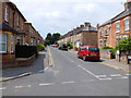
6
St Thomas Rd Dorchester
A small street of victorian terraced houses just off the Bridport Rd alongside the railway
Image: © Nigel Mykura
Taken: 26 Sep 2008
0.06 miles
7
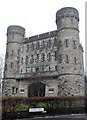
The Keep Military Museum, the Military Museum of Devon and Dorset
Image: © Iain Lees
Taken: 28 Dec 2010
0.07 miles
8
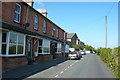
Terraced houses - Bridport Road
This row of terraced houses is situated opposite the hospital in Dorchester.
Image: © Sarah Smith
Taken: 19 Mar 2009
0.07 miles
9
Terraced houses - Bridport Road
Near the end of the Bridport Road the Military Museum is visible and the start of High West Street which is the other side of the Top o'Town roundabout. The trees along the road have been well-pruned in municipal fashion and used to extend as a line from the Military Museum becoming an avenue on leaving the town and stretching out into the countryside to beyond where Poundbury is today.
Image: © Sarah Smith
Taken: 21 Mar 2009
0.07 miles
10
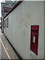
Dorchester: postbox № DT2 56, St. Thomas Road
This postbox is numbered rather haphazardly – the Dorchester town postocde is DT1, with DT2 covering a vast rural area around it. This is thus the only box in the town numbered DT2 rather than DT1.
The box is set into a wall behind the Sydney Arms pub, which frontages onto Bridport Road, and it is emptied finally at 5:15pm on weekdays and at 11:30am on Saturdays.
Image: © Chris Downer
Taken: 10 Apr 2010
0.07 miles