IMAGES TAKEN NEAR TO
York Terrace, DORCHESTER, DT1 2DP
Introduction
This page details the photographs taken nearby to York Terrace, DT1 2DP by members of the Geograph project.
The Geograph project started in 2005 with the aim of publishing, organising and preserving representative images for every square kilometre of Great Britain, Ireland and the Isle of Man.

There are currently over 7.5m images from over14,400 individuals and you can help contribute to the project by visiting https://www.geograph.org.uk
Image Map (Loading...)


Getting Data...Please wait
Leaflet Map data © OpenStreetMap
Images are licensed for reuse under creativecommons.org/licenses/by-sa/2.0
Notes
- Clicking on the map will re-center to the selected point.
- The higher the marker number, the further away the image location is from the centre of the postcode.
Image Listing (76 Images Found)
Images are licensed for reuse under creativecommons.org/licenses/by-sa/2.0
Image
Details
Distance
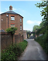
1
York Terrace, Barnes Way (unadopted)
The title is exactly what it says on the street name sign. There is a separate part of Barnes Way about 100m to the SW. Modern road and housing development have obliterated part of the middle section of this road and turned another part into a foot path. This part of the road York Terrace was never adopted by the local authority although a short length just to the north has.
Image: © Nigel Mykura
Taken: 19 Jan 2010
0.02 miles
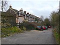
2
Track between South Court Avenue and Kings Road, Dorchester
Image: © Gary Rogers
Taken: 11 May 2017
0.03 miles
3
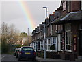
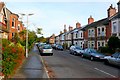
Monmouth Road Rainbow
This is the very eastern end of Monmouth Rd east of the Junction with Culliford Road North. On the right can just be seen the entrance to the Bakers Arms Pub.
Image: © Nigel Mykura
Taken: 23 Jan 2012
0.05 miles
4
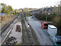
Railway in Dorchester
View east along the tracksfrom the road bridge where Culliford Rd crosses the tracks. The terraced houses on the right are in Monmouth Rd and the road on the left is Prince of Wales Rd
Image: © Nigel Mykura
Taken: 28 Jan 2010
0.05 miles
5
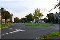
Eastern end of South Court Avenue Dorchester
This roundabout is where Culliford Rd, Barnes Way and South Court Avenue meet up with Lucetta Drive
Image: © Nigel Mykura
Taken: 9 Oct 2008
0.05 miles
6
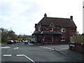
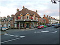
Bakers Arms Pub , Dorchester
Situated at the junction of Monmouth Rd and Culliford Rd this pub used to be a bakery and the old ovens are still a feature inside.
Image: © Nigel Mykura
Taken: 1 Apr 2008
0.05 miles
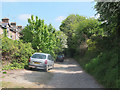
7
Culliford Road South, Dorchester
Culliford Rd runs south from Prince of Wales Road across the railway to the Manor park area of Dorchester. This is the view from the southern end near South Court Avenue looking north.
Image: © Nigel Mykura
Taken: 9 Oct 2008
0.05 miles
8
Bakers Arms Pub
On the roundabout at the eastern end of Monmouth road close to the bridge over the railway. The pub still has some of the old ovens preserved on the walls of the pub that were in the bakery that used to be here.
Image: © Nigel Mykura
Taken: 18 Sep 2011
0.06 miles
9
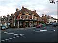
Bakers Arms Monmouth Rd
This old pub was once a bakery. It stands on the corner at a mini roundabout where Monmouth Rd crosses Culliford road right next to the bridge over the railway track.
Image: © Nigel Mykura
Taken: 18 Sep 2011
0.06 miles