IMAGES TAKEN NEAR TO
Glyde Path Road, DORCHESTER, DT1 1XB
Introduction
This page details the photographs taken nearby to Glyde Path Road, DT1 1XB by members of the Geograph project.
The Geograph project started in 2005 with the aim of publishing, organising and preserving representative images for every square kilometre of Great Britain, Ireland and the Isle of Man.

There are currently over 7.5m images from over14,400 individuals and you can help contribute to the project by visiting https://www.geograph.org.uk
Image Map (Loading...)


Getting Data...Please wait
Leaflet Map data © OpenStreetMap
Images are licensed for reuse under creativecommons.org/licenses/by-sa/2.0
Notes
- Clicking on the map will re-center to the selected point.
- The higher the marker number, the further away the image location is from the centre of the postcode.
Image Listing (834 Images Found)
Images are licensed for reuse under creativecommons.org/licenses/by-sa/2.0
Image
Details
Distance
1
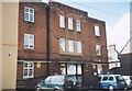
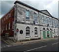
Art Deco, Glyde Path House, Glyde Path Road, Dorchester
On first seeing this building I thought it was an old art deco cinema but I cannot find any records to show this and a Google satellite view shows an inner courtyard. The building is currently occupied by the Inland Revenue.
Image: © Alan Cooper
Taken: Unknown
0.00 miles
2
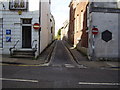
Glyde Path Road
Formerly Shire Hall Lane. The Council offices are situated up on the left.
Image: © Anthony Vosper
Taken: 30 Oct 2012
0.00 miles
3
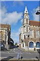
Dorchester: View of the Clock Tower on the corner of The Bow
Image: © Mr Eugene Birchall
Taken: 25 Oct 2009
0.01 miles
4
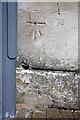
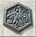
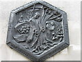
Benchmark on Shire Hall
Ordnance Survey 1GL bolt benchmark described on the Bench Mark Database at http://www.bench-marks.org.uk/bm24942
Image: © Roger Templeman
Taken: 11 Sep 2012
0.02 miles
5
Shire Hall, Dorchester
On the corner of High West Street and Glyde Path Road.
This building was where the Tolpuddle Martyrs http://www.geograph.org.uk/photo/2539637 were tried in 1834.
Image: © Jaggery
Taken: 22 Jun 2014
0.02 miles
6
Dorchester - Tolpuddle Martyrs
Commemorative plaque (150th anniversary) at Shire Hall in High West Street where the trial of the Tolpuddle martyrs took place.
Image: © Colin Smith
Taken: 26 Jun 2019
0.02 miles
7
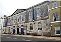
Shire Hall, Dorchester
View from south east. https://historicengland.org.uk/listing/the-list/list-entry/1119069
Image: © Sandy Gerrard
Taken: 2 Sep 2020
0.02 miles
8
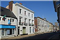
57 High West Street
Offices of the Rifle Volunteers in 1911.
Image: © John M
Taken: 16 Sep 2014
0.02 miles
10
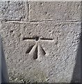
Ordnance Survey 1GL Bolt
This OS cut mark can be found on the south face of the Shire Hall. It marks a point 73.311m above mean sea level.
Image: © Adrian Dust
Taken: 28 Apr 2016
0.02 miles