IMAGES TAKEN NEAR TO
Lubbecke Way, DORCHESTER, DT1 1WQ
Introduction
This page details the photographs taken nearby to Lubbecke Way, DT1 1WQ by members of the Geograph project.
The Geograph project started in 2005 with the aim of publishing, organising and preserving representative images for every square kilometre of Great Britain, Ireland and the Isle of Man.

There are currently over 7.5m images from over14,400 individuals and you can help contribute to the project by visiting https://www.geograph.org.uk
Image Map
Images are licensed for reuse under creativecommons.org/licenses/by-sa/2.0
Notes
- Clicking on the map will re-center to the selected point.
- The higher the marker number, the further away the image location is from the centre of the postcode.
Image Listing (36 Images Found)
Images are licensed for reuse under creativecommons.org/licenses/by-sa/2.0
Image
Details
Distance
1
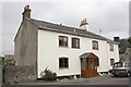
#77 St Georges Road
There is an OS benchmark Image on the house's black skirt at its junction with the stone wall on its left
Image: © Roger Templeman
Taken: 23 Sep 2013
0.05 miles
2

Benchmark on #77 St Georges Road
Ordnance Survey cut mark benchmark described on the Bench Mark Database at http://www.bench-marks.org.uk/bm51780
Image: © Roger Templeman
Taken: 23 Sep 2013
0.05 miles
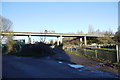
3
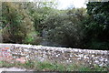
Southeast parapet of Long Bridge
The bridge takes a track over the River Frome. Patching of the brickwork has meant the loss of an Ordnance Survey benchmark which was over the centre of the river
Image: © Roger Templeman
Taken: 23 Sep 2013
0.08 miles
4
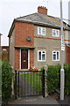
#55 St Georges Road
There is an OS benchmark Image above the side path on the bricks at the front corner
Image: © Roger Templeman
Taken: 23 Sep 2013
0.10 miles
5
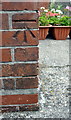
Benchmark on #55 St Georges Road
Ordnance Survey cut mark benchmark described on the Bench Mark Database at http://www.bench-marks.org.uk/bm51779
Image: © Roger Templeman
Taken: 23 Sep 2013
0.10 miles
6
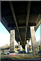
A35 Louds Mill Flyover
This is the underside of the A35 Dorchester bypass flyover where it crosses the River Frome as seen from St Georges Rd.
Image: © Nigel Mykura
Taken: 30 Jan 2015
0.12 miles
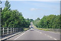
8
A35 Louds Mill Flyover
This flyover carries the A35 Dorchester bypass over the valley of the River Frome which at this point is fairly wide and flat with numerous small watercourses as well as the main river. The view is from St. Georges Rd which leads to Louds Mill.
Image: © Nigel Mykura
Taken: 30 Jan 2015
0.14 miles
9
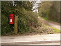
Dorchester: postbox № DT1 196, St. George?s Road
This postbox serves pretty much the only part of Dorchester which spills out beyond the southern by-pass. It is emptied finally at 5:30pm on weekdays and at 11:30am on Saturdays.
Image: © Chris Downer
Taken: 10 Apr 2010
0.14 miles
10

Junction of St Georges Road and track to Syward Road
There is an OS benchmark Image on the roadside stone between the post box and the left edge of the image
Image: © Roger Templeman
Taken: 23 Sep 2013
0.15 miles