IMAGES TAKEN NEAR TO
York Road, DORCHESTER, DT1 1QA
Introduction
This page details the photographs taken nearby to York Road, DT1 1QA by members of the Geograph project.
The Geograph project started in 2005 with the aim of publishing, organising and preserving representative images for every square kilometre of Great Britain, Ireland and the Isle of Man.

There are currently over 7.5m images from over14,400 individuals and you can help contribute to the project by visiting https://www.geograph.org.uk
Image Map
Images are licensed for reuse under creativecommons.org/licenses/by-sa/2.0
Notes
- Clicking on the map will re-center to the selected point.
- The higher the marker number, the further away the image location is from the centre of the postcode.
Image Listing (515 Images Found)
Images are licensed for reuse under creativecommons.org/licenses/by-sa/2.0
Image
Details
Distance
1
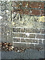
Benchmark at wall junction of #9 Prince of Wales Road
Ordnance Survey cut mark benchmark described on the Bench Mark Database at http://www.bench-marks.org.uk/bm25240
Image: © Roger Templeman
Taken: 20 Sep 2010
0.03 miles
2
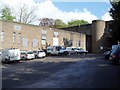
Dorchester Telephone Exchange
Dorchester Telephone Exchange in South Walks Road. It has been extended over the years to accommodate equipment and offices.
Image: © Geoff Trim
Taken: 27 Apr 2009
0.04 miles
3
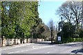
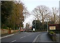
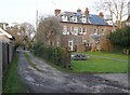
York Rd
York Rd is a small residential road that links Culliford Rd with Prince of Wales Rd.
Image: © Nigel Mykura
Taken: 13 Apr 2009
0.04 miles
4
Benchmark on #32 Prince of Wales Road
Ordnance Survey cut mark benchmark described on the Bench Mark Database at http://www.bench-marks.org.uk/bm25239
Image: © Roger Templeman
Taken: 20 Sep 2010
0.05 miles
5
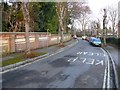
Junction of Prince of Wales Rd and York Rd
View east from Prince of Wales Rd with York Rd going off on the left. Several of the huge victorian houses on Prince of Wales Rd have been converted to residential care homes.
Image: © Nigel Mykura
Taken: 26 Jan 2010
0.05 miles
6
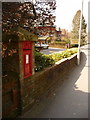
Dorchester: postbox № DT1 90, Prince of Wales Road
Beyond this George V-reign postbox, which is set into a brick pillar opposite York Road, we look along the pavement of Prince of Wales Road towards the town centre. The box is emptied finally at 5:30pm on weekdays and at 11:30am on Saturdays.
Image: © Chris Downer
Taken: 10 Apr 2010
0.05 miles
7
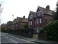
Victorian villas , Dorchester, Dorset
These large houses are on a road originally one of the wealthiest, Prince of Wales Road with many fine Victorian houses. Some have been converted to residential homes and other businesses, and one or two demolished to be replaced with apartment blocks.
Image: © Nigel Mykura
Taken: 2 Mar 2008
0.06 miles
8
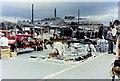
Market Day Dorchester
Wednesday is market day. It looks as if the heavens are about to open on all that cloth and fabric. In the distance one can see the roofs and chimney of Pope's Brewery.
Image: © Sarah Smith
Taken: Unknown
0.07 miles
9
Victorian House Prince of Wales Rd
This is the back of one of the large houses on this road. many of them are so big they have been split into flats. The track on the left is one of the access points into the Brewery Square development site.
Image: © Nigel Mykura
Taken: 27 Jan 2010
0.07 miles
10
York Rd, Dorchester
York Rd is a short road connecting Culliford Rd north with Prince of Wales rd. This is the view east towards Culliford Road North. Formerly some very big Victorian houses were built here but some have been demolished over the years and been replaced with higher density housing.
Image: © Nigel Mykura
Taken: 26 Jan 2010
0.07 miles