IMAGES TAKEN NEAR TO
Casterbridge Industrial Estate, London Road, DORCHESTER, DT1 1PL
Introduction
This page details the photographs taken nearby to Casterbridge Industrial Estate, London Road, DT1 1PL by members of the Geograph project.
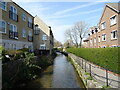
The Geograph project started in 2005 with the aim of publishing, organising and preserving representative images for every square kilometre of Great Britain, Ireland and the Isle of Man.

There are currently over 7.5m images from over14,400 individuals and you can help contribute to the project by visiting https://www.geograph.org.uk
Image Map
Images are licensed for reuse under creativecommons.org/licenses/by-sa/2.0
Notes
- Clicking on the map will re-center to the selected point.
- The higher the marker number, the further away the image location is from the centre of the postcode.
Image Listing (374 Images Found)
Images are licensed for reuse under creativecommons.org/licenses/by-sa/2.0
Image
Details
Distance
1
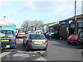
Casterbridge Industrial Estate, Dorchester
One of the many places that uses Thomas Hardy's name for the town. This small industrial estate on the northern edge of the town is packed with small companies many of them automobile repair shops.
Image: © Nigel Mykura
Taken: 1 Apr 2008
0.01 miles
2

Iris
Yellow irises flowering in the damp water meadows alongside the river Frome in Dorchester
Image: © Nigel Mykura
Taken: 25 May 2008
0.05 miles
3
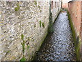
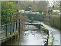
Overflow Channel, Dorchester
This overflow channel running between buildings close to the London Road in Dorchester takes water from the southern branch of the Frome close to the town across the water meadows to the northern branch of the river.
Image: © Nigel Mykura
Taken: 1 Apr 2008
0.05 miles
4
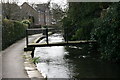
River Walk near Swan Bridge Court
One of the many small foot bridges that cross the Mill Stream
Image: © DorsetBlogger
Taken: 29 Mar 2008
0.05 miles
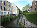
5
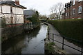
River Frome, Dorchester
Looking north from the main road where the High East Street and London Road meet.
Image: © Jonathan Billinger
Taken: 16 Jan 2009
0.06 miles
6
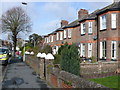
London Rd Dorchester
Victorian terraced housing. This is the eastward continuation of Dorchester's high street and it runs from the bottom of town to Grey's Bridge
Image: © Nigel Mykura
Taken: 1 Apr 2008
0.06 miles
7
River Walk next to Swan Bridge Court
The mill stream flows between the White Hart (disused pub) on the left and Swan Bridge Court on the right.
Image: © DorsetBlogger
Taken: 29 Mar 2008
0.06 miles
8
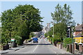
London Road, Dorchester, Dorset
Looking in the direction of Dorchester town centre.
Image: © Peter Trimming
Taken: 26 Jun 2010
0.08 miles
9
Path along the River Frome, High East Street, Dorchester
Image: © Gary Rogers
Taken: 11 May 2017
0.08 miles