IMAGES TAKEN NEAR TO
Wollaston Road, DORCHESTER, DT1 1EQ
Introduction
This page details the photographs taken nearby to Wollaston Road, DT1 1EQ by members of the Geograph project.
The Geograph project started in 2005 with the aim of publishing, organising and preserving representative images for every square kilometre of Great Britain, Ireland and the Isle of Man.

There are currently over 7.5m images from over14,400 individuals and you can help contribute to the project by visiting https://www.geograph.org.uk
Image Map
Images are licensed for reuse under creativecommons.org/licenses/by-sa/2.0
Notes
- Clicking on the map will re-center to the selected point.
- The higher the marker number, the further away the image location is from the centre of the postcode.
Image Listing (734 Images Found)
Images are licensed for reuse under creativecommons.org/licenses/by-sa/2.0
Image
Details
Distance
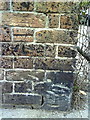
1
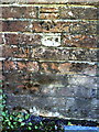
Benchmark on wall of Wollaston Road
Ordnance Survey cut mark benchmark described on the Bench Mark Database at http://www.bench-marks.org.uk/bm35601
Image: © Roger Templeman
Taken: 20 Sep 2010
0.01 miles
2
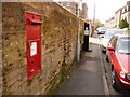
Dorchester: postbox № DT1 86, Wollaston Road
This Victorian postbox, on the shady side of Wollaston Road, is emptied finally at 5:30pm on weekdays and at 11:30am on Saturdays.
Image: © Chris Downer
Taken: 10 Apr 2010
0.01 miles
3

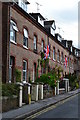
Wollaston Road Dorchester
A quiet residential road lying between the carparks and Icen Way. The road takes its name from a local magistrate Charles Wollaston who was involved with the case of the Tolpuddle Martyrs.
Image: © Sarah Smith
Taken: 14 Aug 2008
0.02 miles
4
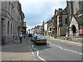
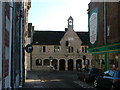
Dorchester
The county town of Dorset. St Peter's church and Dorset County Museum on the right.
Image: © Liz Martin
Taken: 10 Jun 2005
0.02 miles
5
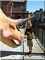
Dinosaur Museum
The Dinosaur Museum in Dorchester
Image: © Steve Edge
Taken: 2 Sep 2005
0.02 miles
6
Napier's Mite, Dorchester
These Almshouses were built and endowed by Sir Robert Napier of Middlemarch in 1616. The building is now a restaurant/coffee bar - execellent cappuccino!
Image: © Dave Napier
Taken: 15 Feb 2005
0.02 miles
7
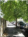
Linden Avenue Dorchester
Named after the trees that line its road - I believe Linden is another name for Lime, please correct me if necessary! Linden Avenue is situated between Wollaston Road and South Walks.
Image: © Sarah Smith
Taken: 14 Aug 2008
0.03 miles
8
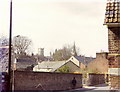
Icen Way - Dorchester
This photograph was taken in the 1970's before the housing development took place on the land behind the wall. The roof of the old Red Cross hut can be seen and in the distance St Peter's and All Saints' churches.
Image: © Peter Fox
Taken: Unknown
0.04 miles
10
Benchmark on wall at entrance to Dorset Fencing & Shed Supplies' yard, Icen Way
Ordnance Survey cut mark benchmark described on the Bench Mark Database at http://www.bench-marks.org.uk/bm25183
Image: © Roger Templeman
Taken: 24 Sep 2010
0.04 miles