IMAGES TAKEN NEAR TO
Cereleton Park, BLANDFORD FORUM, DT11 9PL
Introduction
This page details the photographs taken nearby to Cereleton Park, DT11 9PL by members of the Geograph project.
The Geograph project started in 2005 with the aim of publishing, organising and preserving representative images for every square kilometre of Great Britain, Ireland and the Isle of Man.

There are currently over 7.5m images from over14,400 individuals and you can help contribute to the project by visiting https://www.geograph.org.uk
Image Map
Images are licensed for reuse under creativecommons.org/licenses/by-sa/2.0
Notes
- Clicking on the map will re-center to the selected point.
- The higher the marker number, the further away the image location is from the centre of the postcode.
Image Listing (46 Images Found)
Images are licensed for reuse under creativecommons.org/licenses/by-sa/2.0
Image
Details
Distance
1
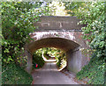
Charlton Marshall Halt
This halt, on the former Somerset & Dorset line, opened on 5th July 1928 and closed from 17th September 1956. The remarkably well-preserved platforms are made out of pre-cast concrete. It's difficult to believe that express trains once belted through here at 70mph, bound for northern cities like Manchester, Liverpool and Sheffield.
When I took the picture, I didn't realise it was almost 53 years to the day that the halt saw its last passengers.
Image: © Peter Kazmierczak
Taken: 16 Sep 2009
0.08 miles
2
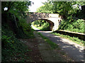
Church Lane, Charlton Marshall
This disused railway bridge, still in very good condition despite not having seen a train in some 40 years, once carried the Somerset and Dorset line over Church Lane.
Image: © Peter Kazmierczak
Taken: 16 Sep 2009
0.09 miles
3
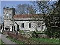
Charlton Marshall (Dorset) St Mary's Church
Image: © ChurchCrawler
Taken: 4 Apr 2003
0.10 miles
4
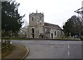
Charlton Marshall, parish church
The Church of St. Mary the Virgin, with C15 roots; listed by English Heritage: http://www.imagesofengland.org.uk/Details/Default.aspx?id=103309&mode=adv
Image: © Mike Faherty
Taken: 22 Feb 2012
0.13 miles
5
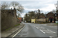
A350 through Charlton Marshall
Heading south.
Image: © Robin Webster
Taken: 1 Apr 2018
0.13 miles
6
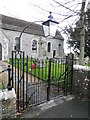
Gates, St Mary's Church
The gates to the churchyard of St Mary's Church.
Image: © Maigheach-gheal
Taken: 26 Feb 2011
0.13 miles
7
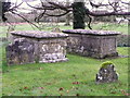
Table tombs, St Mary's Churchyard
These two 18th century table tombs are monuments to John Street, both members of the same family.
Image: © Maigheach-gheal
Taken: 26 Feb 2011
0.13 miles
8
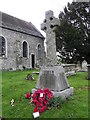
War Memorial, Charlton Marshall
The war memorial is within the churchyard of St Mary's Church.
We will remember them.
Image: © Maigheach-gheal
Taken: 26 Feb 2011
0.13 miles
9
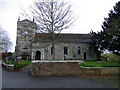
St Mary's Church, Charlton Marshall
The church has its origins in the 15th century. 18th century work probably by the Bastard Brothers of Blandford.
Image: © Maigheach-gheal
Taken: 26 Feb 2011
0.13 miles
10
St. Mary, Charlton Marshall: churchyard (1)
Image: © Basher Eyre
Taken: 19 May 2012
0.13 miles