IMAGES TAKEN NEAR TO
Blandford Road, BLANDFORD FORUM, DT11 8LN
Introduction
This page details the photographs taken nearby to Blandford Road, DT11 8LN by members of the Geograph project.
The Geograph project started in 2005 with the aim of publishing, organising and preserving representative images for every square kilometre of Great Britain, Ireland and the Isle of Man.

There are currently over 7.5m images from over14,400 individuals and you can help contribute to the project by visiting https://www.geograph.org.uk
Image Map
Images are licensed for reuse under creativecommons.org/licenses/by-sa/2.0
Notes
- Clicking on the map will re-center to the selected point.
- The higher the marker number, the further away the image location is from the centre of the postcode.
Image Listing (115 Images Found)
Images are licensed for reuse under creativecommons.org/licenses/by-sa/2.0
Image
Details
Distance
1
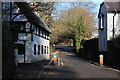
Iwerne Minster, A350 looking North
Narrow section of main A350 Blandford Road at Iwerne Minster looking north toward Shaftesbury. The war memorial is on the right at Higher Street about opposite the car, whilst Clayesmore School is further on the left hand side.
Image: © John Stephen
Taken: 29 Dec 2013
0.02 miles
2
![Iwerne Minster houses [12]](https://s3.geograph.org.uk/geophotos/06/76/87/6768727_9680b562_120x120.jpg)
Iwerne Minster houses [12]
The Old Cottage in Higher Street is a hall house of the early 16th century with the hall floored in the 17th century. There have been alterations in the 18th, 19th and 20th centuries. At one time it was converted into two cottages now reverted to one. Built in a mixture of flint rubble stone and brick with a thatched roof which is supported on four true cruck trusses. Listed, grade II, with details at: https://historicengland.org.uk/listing/the-list/list-entry/1324637
Iwerne Minster is a small village on the edge of the Blackmore Vale, about 5 miles south of Shaftesbury and the same distance north of Blandford Forum. The village is within the Cranborne Chase and West Wiltshire Down Area of Outstanding Natural Beauty. There is evidence of occupation since prehistoric times. The River Iwerne flows from a spring in the middle of the village. The original Minister is now St Mary's Church and was built by the Normans on the site of an earlier church.
Image: © Michael Dibb
Taken: 10 Dec 2020
0.05 miles
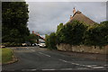
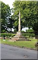
4
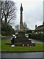
War memorial
Located at the junction of Higher Street and Blandford Road (A350), Iwerne Minster war memorial erected in 1920 was designed by Sir George Gilbert Scott. The memorial is based on the form of a medieval Dorset market cross. Listed, grade II, with details at: https://historicengland.org.uk/listing/the-list/list-entry/1110194
Iwerne Minster is a small village on the edge of the Blackmore Vale, about 5 miles south of Shaftesbury and the same distance north of Blandford Forum. The village is within the Cranborne Chase and West Wiltshire Down Area of Outstanding Natural Beauty. There is evidence of occupation since prehistoric times. The River Iwerne flows from a spring in the middle of the village. The original Minister is now St Mary's Church and was built by the Normans on the site of an earlier church.
Image: © Michael Dibb
Taken: 10 Dec 2020
0.06 miles
6
![Iwerne Minster houses [10]](https://s2.geograph.org.uk/geophotos/06/76/87/6768710_ca3feba0_120x120.jpg)
Iwerne Minster houses [10]
Set back from Shute Lane, Primrose Cottage and Church View are a pair of mid 19th century brick built cottages. Listed, grade II, with details at: https://historicengland.org.uk/listing/the-list/list-entry/1305180
Iwerne Minster is a small village on the edge of the Blackmore Vale, about 5 miles south of Shaftesbury and the same distance north of Blandford Forum. The village is within the Cranborne Chase and West Wiltshire Down Area of Outstanding Natural Beauty. There is evidence of occupation since prehistoric times. The River Iwerne flows from a spring in the middle of the village. The original Minister is now St Mary's Church and was built by the Normans on the site of an earlier church.
Image: © Michael Dibb
Taken: 10 Dec 2020
0.06 miles
7
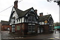
The Wild Garlic at the Talbot Inn, Iwerne Minster
Once The Talbot, renowned for its food and ales. It closed and was taken over by Matt Follas as a restaurant in May 2013 with accommodation and cookery master classes. The restaurant closed at the beginning of November 2013.
To the right of the pub is the site of the petrol station and Garage which is being redeveloped as flats. Will the pub site go the same way? The brewery has been trying to redevelop the stable blocks,and carpark and reduce the size of the pub for some years.
Mr Follas (who won Masterchef in 2008) had previously run The Wild Garlic at Beaminster in West Dorset, but that closed in May 2013 when he transferred the business to Iwerne. Part of the reason for his move was a lack of trade in Beaminster due to the closure of Horn Hill tunnel after a tragic landslip in July 2012. The tunnel reopened in July 2013.
Image: © John Stephen
Taken: 3 Jan 2014
0.07 miles
8
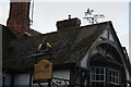
Brewer's sign, restaurant sign and pub weather vane
Signs at the closed Wild Garlic,ex Talbot in Iwerne Minster. The Hall and Woodhouse Badger sign is not so common nowadays and the weather vane showing a hunting scene relates to the original name of the pub, the Talbot being a now extinct hunting dog. The old sign of the pub was a heraldic representation of a black dog, being the coat of arms of the local family named Bower.
Image: © John Stephen
Taken: 3 Jan 2014
0.07 miles
9
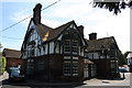
Back to "The Talbot"
The pub in Iwerne Minster has been renamed back to "The Talbot" after its unsuccessful stint as the "Wild Garlic", see Image It should be noted that the sign now has the standard heraldic representation of a Talbot hunting dog in white, rather than that from the local Bower family coat of arms which is black and was on the original pub sign, see Image
Image: © John Stephen
Taken: 30 Jun 2014
0.07 miles
10
![Iwerne Minster houses [11]](https://s2.geograph.org.uk/geophotos/06/76/87/6768726_5b8ee194_120x120.jpg)
Iwerne Minster houses [11]
Bow Cottage and Hill View in Shute Lane are a pair of mid 19th century brick built cottages. The lower extension with the false timber framing is 20th century. Listed, grade II, with details at: https://historicengland.org.uk/listing/the-list/list-entry/1110200
Iwerne Minster is a small village on the edge of the Blackmore Vale, about 5 miles south of Shaftesbury and the same distance north of Blandford Forum. The village is within the Cranborne Chase and West Wiltshire Down Area of Outstanding Natural Beauty. There is evidence of occupation since prehistoric times. The River Iwerne flows from a spring in the middle of the village. The original Minister is now St Mary's Church and was built by the Normans on the site of an earlier church.
Image: © Michael Dibb
Taken: 10 Dec 2020
0.07 miles