IMAGES TAKEN NEAR TO
Stour Road, BLANDFORD FORUM, DT11 7ER
Introduction
This page details the photographs taken nearby to Stour Road, DT11 7ER by members of the Geograph project.
The Geograph project started in 2005 with the aim of publishing, organising and preserving representative images for every square kilometre of Great Britain, Ireland and the Isle of Man.

There are currently over 7.5m images from over14,400 individuals and you can help contribute to the project by visiting https://www.geograph.org.uk
Image Map (Loading...)


Getting Data...Please wait
Leaflet Map data © OpenStreetMap
Images are licensed for reuse under creativecommons.org/licenses/by-sa/2.0
Notes
- Clicking on the map will re-center to the selected point.
- The higher the marker number, the further away the image location is from the centre of the postcode.
Image Listing (16 Images Found)
Images are licensed for reuse under creativecommons.org/licenses/by-sa/2.0
Image
Details
Distance
2
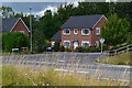
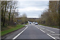
Blandford Forum by-pass dropping into valley of River Stour
The by-pass crosses the wide flood plain between roundabouts for the B3082 and A350. The minor road on the left follows the edge of the flood plain and the by-pass is raised above the fields, hence the crash barriers
Image: © David Smith
Taken: 12 Feb 2016
0.12 miles
3
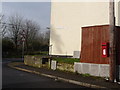
Blandford Forum: postbox № DT11 170, Langton Crescent
This small George VI-reign postbox is just around the corner from Langton Road, which we see beyond and which is so named because it was the road to Langton Long Blandford before it was curtailed by the town bypass.
Image: © Chris Downer
Taken: 19 Feb 2009
0.15 miles
4
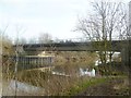
Blandford St Mary, road bridge
Carrying the A354/A350 Blandford Forum Bypass over River Stour.
Image: © Mike Faherty
Taken: 28 Jan 2012
0.17 miles
5
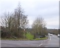
A354 bypassing Blandford Forum
Descending to cross the River Stour.
Image: © Robin Webster
Taken: 1 Apr 2018
0.17 miles
6
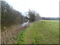
Blandford St Mary, riverside walk
Along the bank of the Stour, on Stour Meadows; in the distance, road bridge on the A354 by-pass.
Image: © Mike Faherty
Taken: 28 Jan 2012
0.17 miles
7
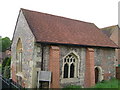
St Leonard's Chapel, Blandford
Blandford's only medieval building, this has its origins as a C13 leper hospital. It was restored in 1996 after being used as a barn.
Image: © Derek Harper
Taken: 6 May 2006
0.17 miles
8
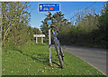
Eleven miles to Wimborne
Entering the village of Langton Long Blandford on Cycle Route 25 in the Stour Valley. The bicycle is a circa 1992 Giant steel-frame rigid.
Image: © michael ely
Taken: 21 Apr 2009
0.18 miles
9
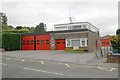
Blandford Fire Station
Blandford Fire Station, St Leonards Avenue, Blandford, Dorset.
Image: © Kevin Hale
Taken: 27 Sep 2006
0.20 miles
10
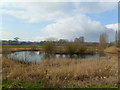
Blandford St Mary, pond
On Stour Meadows, the floodplain of the River Stour; a pond and associated reedbeds. In the distance, modern brewery buildings at Image
Image: © Mike Faherty
Taken: 28 Jan 2012
0.20 miles